Carros Village to Canal de la Gravière

At-Canal-de-la-Gravière


The walk along Canal de la Gravière (about 700 m elev.) above Carros Village (370m) offers great views to Mercantour Summits and the Var River Valley. Local hiking guides call it also Balcon de Carros. We have previously posted hikes in this area: New loop trail above Carros Village and Sommet du Broc.


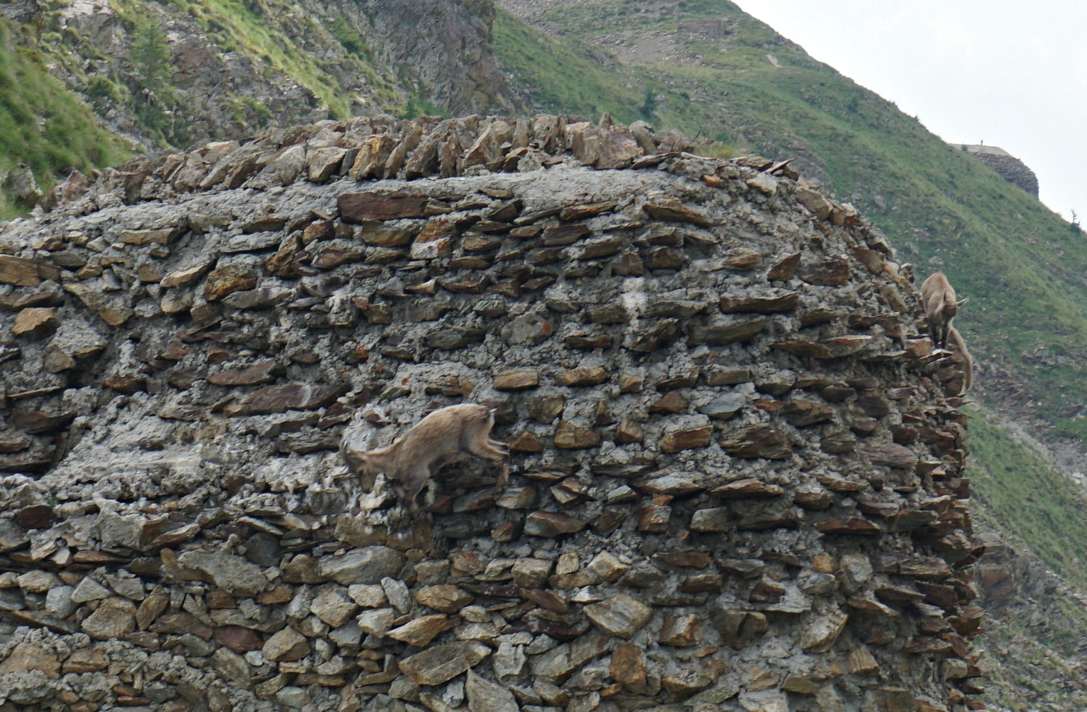
From Carros Village (370m) we started ascending along the path to Sommet du Broc. The path ends in a forest road; the trail to Sommet du Broc forks left, ascending to Canal de la Gravière where the aqueduct running along the mountain flank became visible. The descending dirt road descends to Le Broc.

This time we wanted to explore the northern part of Canal de la Gravière. A partly ingrown piste followed the aqueduct a few hundred meters after which the water duct dove into rocky and steep terrain, marking our turning point and picnic break.

On the way back, we walked the same way as far as to the crossroads by the forest road. From here we continued along it towards Le Broc. Before Le Broc Village, we reached a wider road and a crossroads showing the direction back to Carros Village, passing the Chapel of St-Sébastien. From the Chapel, the itinerary passed tranquil residential areas, following a paved road.

There were new signposts along the trail. Carros Village is a great starting point for day hikes. By taking advantage of the network of marked itineraries, you can easily tailor make your hike. The image below shows the GPS trail.

Duration: 2h15

Climb: 410 m

Canal de la Gravière trail above Carros


Map: 3642 ET Vallée de l’Estéron Vallée du Loup


View from path to Mercantour summits

0 comments:

Note: only a member of this blog may post a comment.

Old-style vegetable soup

Old-style vegetable soup


This vegetable soup recipe is inspired by the French morning TV, Télématin. The presenter first talked about the Sun King Louis XIV, who was very fond of his vegetable garden in Versailles. He was regularly served as a starter vegetable soup made from old-style root vegetables from his garden.

My soup recipe is loosely based on the TV show. The good thing with vegetable soups is that you can easily change the ingredients according to your preferences and seasonal availability.

Serving this soup as a starter is a great way to increase your vegetable intake towards the recommended 3- 5 portions a day. Any leftover soup can be frozen.

Ingredients

2 carrots
2 turnips
2 parsnips
2 Jerusalem artichokes
1 large onion
½ head of cauliflower
3 tbsp. olive oil
 800 ml water
1tsp. curry or Piment d’Espelette
Fresh herbs

Warm the olive oil in a large casserole over medium heat. Peel and chop the vegetables, add to the casserole placing the cauliflower on top. Add the curry and water and bring to the boil.

Cover and reduce to medium heat. Cook for 30 minutes.

With a handheld mixer purée the vegetables. Serve in bowls decorated with chopped fresh herbs.

0 comments:

Note: only a member of this blog may post a comment.

Isola 2000: Mont St-Sauveur 2711 m

Ascending towards Mont Saint-Sauveur


At 2711 m, Mont Saint-Sauveur is the highest peak between the Tinée River Valley and Isola 2000. It offers a great panorama of the surrounding mountains. The view down to the Tinée Valley about 2000 m below is impressive.

The trail from Col de la Valette (2389 m) is alpine, quite stony and in some spots narrow and steep. On the way back, we grew tired of the sharp stones and further down took a parallel ski run/dirt track back to Col de la Valette.


We started from Isola 2000 centre (Front de neige) at signpost #80 well hidden under fir trees. We crossed the valley of Chastillon and walked under a wooden bridge past signpost #81.

The Isola 2000 hiking booklet advises initially to fork left at #81 and to follow Chemin des Italiens, then to climb to signpost #96. We, however, forked right and climbed along ski runs of Pelevos / Mercantour directly to signpost #86 next to the Pelevos Telecabine, saving time and distance. The itinerary then followed easy ski runs as far as to Col de la Valette. From here we continued along a narrow hiking trail that ran in a rocky mountain slope, heading first west, then gradually south.

The summit of Mont St-Sauveur came visible, as well as ruins of old Italian barracks below the summit crest. We reached signpost #89 (2508 m) at the ridge between our goal and Cime de Sistron (2603 m). We forked left and climbed the to the summit. There was a bunker a little below, and another at the mountaintop. High above the Tinée Valley, the mountain had strategic importance as the region used to be Italian territory.

On the way back, we descended a bit more when using the ski runs and dirt tracks, before ascending to Col de la Valette. We therefore recorded about 100 m extra climb (image of GPS track below) .

Vertical gain: 860 m

Duration: About 5 h

Distance: 15 km

Map: IGN 3640 ET Haute Tinée 2 Isola 2000


MtSaint Sauveur trail image


0 comments:

Note: only a member of this blog may post a comment.

Sea bass with fennel, orange and lemon

Sea bass with fennel orange and lemon


The Mediterranean sea bass, loup de mer, is nowadays mostly farmed. Wild seabass from Atlantic waters is in France called bar. It takes about 5 years for a wild sea bass to reach the minimum legal length of 42 cm. It then weighs about 900 g and in our supermarket in Nice costs about 33 euros kilo.

For the following simple recipe, I chose a wild line-caught sea bass, bar de ligne. Make sure that the fish is properly descaled and cleaned.

2 servings

1 wild line-caught sea bass, bar de ligne, about 900g
1 fennel
1 organic orange
1 organic lemon
100 ml white wine
2 tbsp olive oil
A pinch of salt

Preheat the oven to 190° C.

Rinse out the belly cavity of the sea bass and dry with kitchen paper. Rub a pinch of salt in the cavity and fill with thin slices of ½ lemon.

Slice the fennel thinly and place in the bottom of an oven-proof dish which is large enough to hold the fish. Finely grate the zest of the orange and add to the fennel. Add the juice of the orange and ½ lemon. Place the fish on top of the fennel and pour the white wine over it. Sprinkle the olive oil on top of the fish.

Bake for 40- 45 minutes until the fish is done. Take a peek inside the fish or make a deep cut to see if it is opaque. Serve with red quinoa or green lentils and a green side salad.


0 comments:

Note: only a member of this blog may post a comment.

Boréon: Mont Archas

Mont Archas 2526m summit


The 15th of August, L’Assomption, is a public holiday in France. We knew that large crowds would head to the mountains as the weather forecast was favourable, and August is the peak season for mountain activities.

To be able to find a parking spot in Le Boréon, we tried to leave early. When we arrived, the Salèse Valley parking was almost full. In addition, we saw that there was a fête patronale in Mollières, now a ghost village on the other side of Col de la Salèse. There was a lot of car traffic apparently heading there as the track that normally is closed had been opened for this event. So, the normally quite tranquil Salèse Valley was very busy that morning!

We had chosen to do a hike “off the beaten track”, first towards Lacs des Adus, then up to Mont Archas (2526 m) via Col de la Valette des Adus (2356 m) as we knew that most hikers would head to Lac Negre, Col de Cerise etc where chamois may be spotted.


We started from signpost #434 at the parking, crossed the stream to signpost 397, and followed the trail that climbed steeply in the woods. We then passed a private refuge and Lacs des Adus. Most of the lakes were dry. We met only sporadic hikers and a few trail runners. We continued the ascent towards Col de la Valette des Adus, now above the tree line. The trail followed the border of the Mercantour National Park. From the col (signpost #394), we continued east along a well-marked trail towards Mont Archas already well visible in front of us. The yellow markings along the trail were new as the route is used by the trail runners.

After a break at the saddle between Cime de la Valette and Mont Archas we were ready for the last 160 m climb to the summit. There were many trails, and we followed the one with yellow markings. The summit itself was marked with a large cairn. The 360° panorama view was quite stunning: Argentera, Cime du Gélas, you name it! The town of Saint-Martin-Vésubie was 1500 m below us.

From the summit, we started the descent heading east, still using the trail runners’ itinerary. The initial descent was steep and rocky along a ridge, so our respect for trail runners increased even more!

Eventually we came to a crossroads at signpost #393 and forked left to Les Adus, the area which we passed in the morning. At signpost #396, a little below the private refuge mentioned above, we closed the loop and headed back to our starting point in the Salèse Valley.

Parts of the trail were rocky and hence more strenuous. The ascent from the valley was more or less continuous. However, navigation was easy as the signposts and marking were new.

Elevation gain: 882 m (Our log)

Distance: 14 km
Mont Archas trail

Duration: 5h 30

Map: 3741 OT Vallée de la Vésubie


0 comments:

Note: only a member of this blog may post a comment.

White bean and red quinoa salad

White bean and red quinoa salad


The following salad recipe makes a light and tasty lunch. It is full of vegetable protein, which we should be eating more of, antioxidants and heart-healthy olive oil.

2 servings

A tin of white beans
100 ml red quinoa
About 10 red cherry tomatoes
About 10 yellow cherry tomatoes
1 spring onion
A generous handful of baby salad leaves, mesclun
Freshly ground black pepper
Basil leaves to decorate
Dressing:
1 tbsp. red wine vinegar
4 tbsp. olive oil

Cook the red quinoa in 250 ml water for 20 minutes. Let cool in a bowl.

Rinse the white beans under running water and add to the bowl.

Wash the cherry tomatoes, cut into halves and add to the bowl. Wash the spring onion, slice it including the green part and add to the bowl. Grind over some black pepper.

Whisk the dressing in a small bowl, add to the vegetables and mix. Gently fold in the salad leaves. Divide the mixture in two bowls and decorate with basil leaves.

0 comments:

Note: only a member of this blog may post a comment.

Planetary trail above Valberg

Planet Saturn by the trail from Valberg


This relaxed walk starts from Valberg ski resort (1680 m) about 80 km from Nice. Valberg is built in a classic alpine style and has an atmosphere of a larger, chic resort.

The trail is called Sentier Planétaire, the planetary path, because it is dedicated to astronomy; at various spots you will discover the sun, the earth and seven other planets as well as information about the milky way, galaxies etc. It is a great hike for kids too.

In summer, some trails are dedicated to hikers, others to mountain bikers. From many spots you’ll be able to see the village and signposts are numerous along the trails. You will not get lost here! You can benefit from the crisscrossing paths and dirt roads and tailor-make your walks if you wish.


We modified the itinerary by taking the planetary trail on the way back, and by making an extension to a nearby summit called L’Adrech de Forche (2011 m).
From the centre of Valberg we started ascending along a road first to Lac de Sénateur then further to a crossroads and signpost #20 where we came to the planetary trail proper. The itinerary continued in the woods to a small summit with the planet Uranus.

A short descent then took us to Col des Anguillers (1854 m, signpost #24), next to Lac des Anguillers. From here, we climbed along the trail, zigzagging in the woods up to the turning point of the planetary trail and the planet Neptune (1926 m).

The summit of L’Ardeche de Forche was visible in the southeast. We descended about 50 m from Neptune then climbed up to the summit which was our turning point. Dome de Barrot was visible in the south while the long ridge of Mont Mounier dominated the scene in the north east.

On the way back to Valberg, we used the dirt road to signpost #20, then the very picturesque path running along the western slope of the mountain (signposts # 11,10,9) with further astronomic information (albeit only in French) in several places.

Even if you wouldn’t be interested in the theme itself, this walk along good trails offers truly great views.

Duration: 4 h
Our planetary trail track Valberg

Distance: 11 km

Elevation gain: 450 m (our variant)

Map: “Haut Cians” 3640 OT


0 comments:

Note: only a member of this blog may post a comment.

Turkey escalopes Milan style

Turkey escalopes Milan style


In the following recipe hazelnut powder, noisettes en poudre, is used instead of the usual breadcrumbs. This gives a nice nutty taste for the dish. In France we can buy hazelnut powder in ordinary supermarkets, but it is easy to make with a kitchen machine. Any leftover hazel powder can be added in your morning muesli.

2 servings

2 turkey escalopes
1 egg
2 tbsp. flour
2 tbsp. hazelnut powder
2 tbsp. olive oil
Sauce:
2 tbsp. good mayonnaise
2 tsp. Dijon mustard

Preheat the oven to 180° C.

In a bowl, whisk the egg. Spread the flour on one plate and hazelnut powder on another plate. Warm the olive oil over medium-high heat in a large frying pan.

Dip the escalope first in egg, then in flour, then in hazelnut powder and fry on both sides until golden brown. Transfer the escalope on an oven dish and bake in the oven for 15- 20 minutes depending on thickness.

Meanwhile microwave some new potatoes and wilt three to four handfuls of baby spinach. Make a sauce by whisking together the mayonnaise and Dijon mustard. Divide the sauce in small bowls and place on the plates.

Divide the escalopes, new potatoes and wilted spinach on the plates and serve at once.

0 comments:

Note: only a member of this blog may post a comment.

Isola 2000: Pas du Loup

The lake before Pas du Loup Isola2000


We wanted to explore another trail heading to Pas du Loup (2665m), a mountain pass at the Italian border above Isola2000. We have previously hiked from Isola2000 to Baisse de Druos, also at the Franco-Italian border.

The trail to Pas du Loup forks left from the main artery at signpost #93 near the Lakes of Terre Rouge. The trail up to a small lake is easy. After the lake the path is much narrower and truly alpine.


On a gorgeous August day, we parked at the end of a small street Front de Neige, with blue lamp posts (2080m). We started to ascend along a grassy ski run. The trail soon became much rockier, and we crossed a rock slide.

We continued ascending along the popular trail to Baisse de Druos until we turned left at signpost #93 and soon reached a small lake with no name on the map. The trail seemed to be off the beaten path. Only sporadic hikers ascended here.  Pas du Loup was well visible from the lake. We followed the zigzagging trail that mostly ran in a rocky terrain.

The pass comprised a narrow ridge with steep mountains both sides. The northern incline of the pass on the Italian side was partly snow-covered. Certainly not your everyday border crossing!

We descended back along the same trail.

Elevation gain: 630 m
Pas du Loup trail image

Duration: about 3h 45

Distance: 9 km

IGN map: 3640 ET Haute Tinée 2 Isola 2000


0 comments:

Note: only a member of this blog may post a comment.