Trout with tapenade, lentils, and saffron sauce
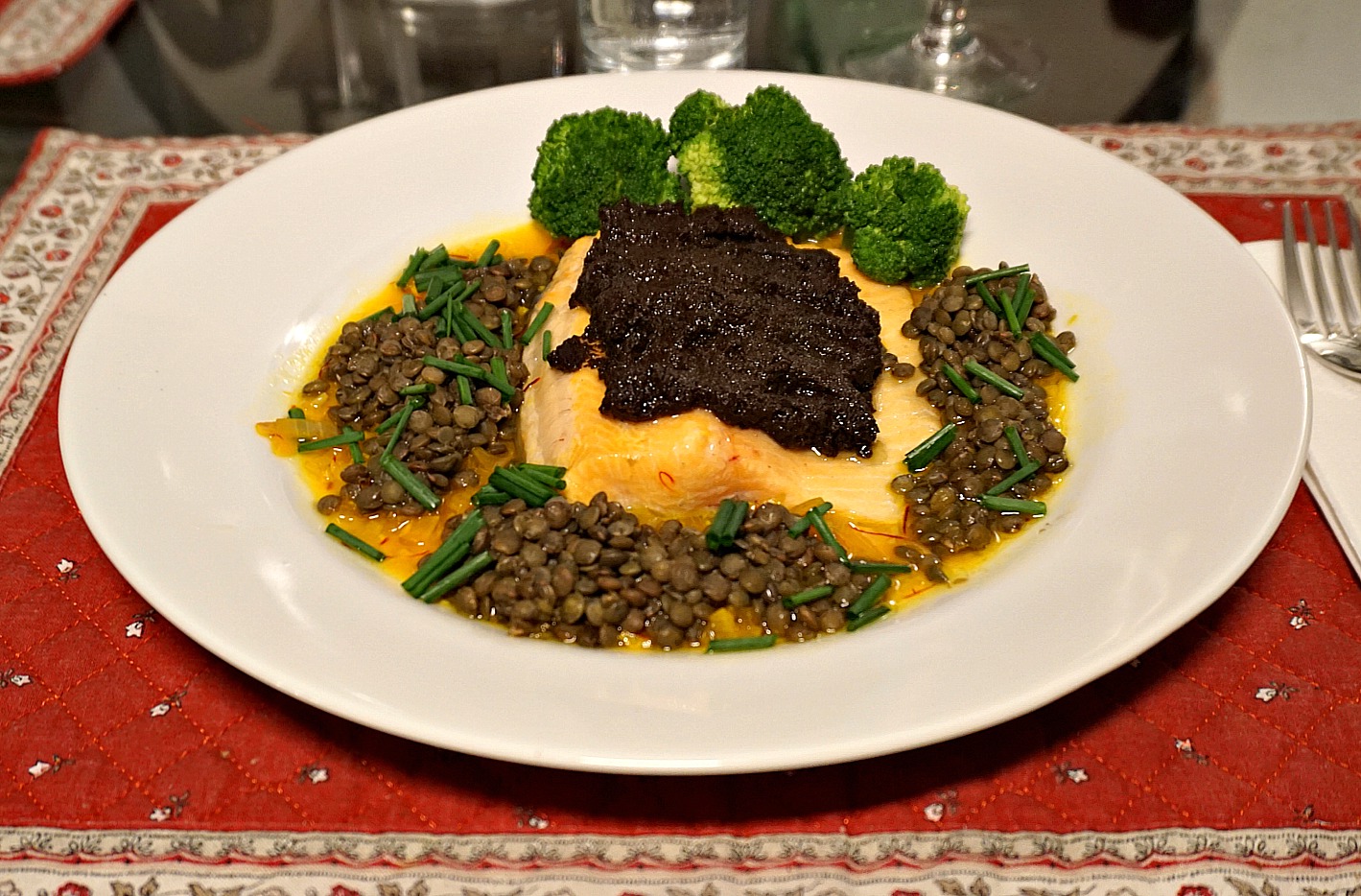
Trout with tapenade, lentils, and saffron sauce


This recipe was inspired by an article in the magazine Paris Match. A known Annecy chef told about his trout recipe made from local ingredients. The trout was covered with poutargue de lotte du lac d’Annecy; burbot roe probably salted and dried like poutargue in Provençe.

I wanted to use local ingredients from our supermarket and organic vegetable shop in Nice and compose my recipe from the photo in the article. The result was so good that I want to share it and encourage you to twist this recipe according to your local ingredients.

2 servings

2 pieces of fresh trout fillet
4 tsp. tapenade noir
100 ml green lentils, organic
½ broccoli
Chopped chives

For the sauce:

1 shallot, chopped
1 clove garlic, minced
2 tbsp. olive oil
200 ml white wine
Pistils of saffron

Start by cooking the lentils. They need to be cooked for about 25 minutes to be soft but not falling apart. Add a little water if needed. When they are done, cover and keep warm. Any leftover lentils can be added in salads.

In a small saucepan, warm the olive oil over medium heat and sauté the shallot and garlic for a few minutes. Add the white wine and saffron and continue cooking until the sauce has reduced to about half.

Warm the oven to 200° C.

Place the trout pieces in an oven-proof dish and roast for about 7- 10 minutes depending on the thickness of the fillet.

While the fish is roasting, steam or microwave a few broccoli florets. Place the trout pieces in the middle of the plates and spread 2 teaspoons of tapenade on top. Divide the sauce around the fish and place the lentils and broccoli on top of the sauce. Decorate with chopped chives.

0 comments:

Note: only a member of this blog may post a comment.

Vars: Hike around Peynier Mountain


Peynier (2273 m) attracts walkers because of an easy access along a dirt road from Refuge Napoleon, and of course a super panorama from the mountain top.  Most of the mountain’s flanks are forest-covered.

Hiking and trail-running paths circle Peynier. We wanted to explore these, and hike around the mountain.

Peynier southern slope
Vars and Point de l'Eyssina(L)
Dirt track in Bois Noir Vars
Peynier ski run facing north

We started from Vars les Claux, and walked towards Refuge Napoleon as far as to the dirt track which connects the Refuge and Peynier. We forked left and ascended gently along it as far as to a crossroads and a signpost where we took the left-hand trail (also a dirt track, see image+arrow) which continued straight and almost horizontally to Bois Noir, the forest covering Peynier’s western flank.

A clearing in Bois Noir Peynier
Bridge over Torrent du Vallon
Ascending east of Torrent du Vallon
Crête de Vars in background

We walked past a few ski runs and gradually turned to the east, descending simultaneously. The dirt track ended, and we continued along a path that descended to Pont d’Entraigues (1865 m; the lowest point of this hike). We crossed Torrent du Vallon, forked left (north) and soon reached another crossroads with a wide dirt track. We forked sharply right (south) and ascended along the eastern side of Torrent du Vallon, first in the woods. We left the dirt track and continued along a path (yellow markings).  There was a menacing thunderstorm approaching the valley. Fortunately, we got just a few drops as the main storm changed its direction. We now had Peynier’s eastern flank on our right-hand side, and the telecom mast on the summit came visible.

Crossing Torrent du Vallon higher up
Ascending to Peynier
Climbing to Crête de la Mayt Peynier
Almost at Crête de la Mayt Peynier

We reached a clearing and a crossroads signposted “Peynier”. We forked right, crossed the torrent again (not a bridge, just two tree trunks over the water). We climbed a bit more before we reached the ridge at 2213 m elev. (Crête de la Mayt) south of Peynier. We circled around a water reservoir, then reached the main dirt road from the summit. We descended along it all the way to the crossroads to Vars, and took the hiking path back to the village.

Images are displayed in chronological order.

Distance: 14 km

Climb: 530 m

Duration: 4h45       

Map: 3537 ET “Guillestre Vars Risoul”

Peynier loop hike
Peynier loop hike

0 comments:

Note: only a member of this blog may post a comment.

Risoul: Belvédère de l'Homme de Pierre loop hike

Crête de Martinat Risoul


Risoul (1850 m), a mountain resort above Guillestre, offers several great hiking itineraries during the summer season. 

We are in the Southern French Alps, in the department of Hauts-Alps.

The following loop hike must be one of the most popular walks in Risoul. We saw families on the trail. Some of them might have just hiked to the mountain top and back, instead of completing the loop.

Start of trail at Pelinche Risoul
Signpost at 1975m Risoul
View to east from Risoul
Larch forest above Risoul

We started from the spacious Pelinche chair lift parking (1900 m), located the dirt track which ran under the Pelinche ski lift and ascended to a crossroads with a signpost ( elev.1975 m; 2nd image) showing the itinerary to the summit. We forked left and ascended along a trail, initially in a larch wood. We crossed another path in a clearing and continued the ascent.

View to northeast from Risoul
Short steep section of trail above Risoul
l'Homme de Pierre in sight

The path soon turned to southwest, we left the woods and had alpine meadows on both sides. We climbed over a small summit and had Belvédère de l’Homme de Pierre (2374 m) in sight (a telecom mast, ski lift). The summit marked the highest point of this hike. 

We continued the circuit by following the path to the northwest then north where we descended along the magnificent Crête de Martinat. This part of the hike was definitely the highlight of the itinerary. We had the Durance River Valley deep under us. Further away, we had a glimpse of Lake Serre Ponçon.

Belvédère de l'Homme de Pierre summit
Leaving l'Homme de Pierre summit
Serre Ponçon Lake seen from Risoul

We eventually reached a dirt track, a clearing with a hut and a picnic table. At this point, we forked sharply right (southeast) and walked past Lac du Pré du Laus, then ascended a bit before descending back to Risoul along the same track.

Image of our track below 

Duration: 4 h

Distance: 12 km

Climb: 570 m

Map: 3537 ET “Guillestre Vars Risoul”

Risoul loop track
Risoul loop track

0 comments:

Note: only a member of this blog may post a comment.

Black rice risotto with shrimp


Black rice has the most anti-oxidants of all the rice types. No wonder that in the Ancient China it was reserved to the Emperor and his extended family. Nowadays in Nice we can buy Italian black rice from supermarkets and Asian black rice from organic food shops.

The following Black rice risotto recipe is inspired by a newsclip on the French morning TV TeleMatin. I didn’t follow the French chef’s recipe; I simply prepared my black rice risotto like a classic risotto from carnaroli or arborio rice, see Risotto with scallops. But there are two differences: the cooking time for black rice is longer about 45 minutes, unless it is parboiled which has about 20 min. cooking time. You won’t achieve the creaminess of the classic risotto because black rice is a whole grain. So, there is no point stirring it continuously while cooking, just occasionally.

Serve the black rice risotto with cooked and peeled shrimp, wilted spinach and roasted cherry tomatoes.

2 servings

120 ml black rice
Olive oil
1 shallot, chopped
1 clove garlic, minced
150 ml white wine
About 900 ml chicken stock (you may not use it all)
A handful of grated parmesan
Freshly ground black pepper
About 200 g cooked and peeled shrimp
Fresh basil leaves, chopped
2 handfuls of baby spinach
About 10 cherry tomatoes

In a large heavy casserole, warm 2 tbsp. olive oil over medium-low heat and gently sauté the shallot and garlic for about 5 minutes. Add the rice and stir until well coated by oil. Raise the heat to medium- high and pour in the wine. Stir occasionally.

When the wine has evaporated, add about 200 ml stock. Stir occasionally and add more stock in batches after the previous one has evaporated. There should always be some liquid in the casserole. The rice should be done after 45 minutes. When the rice is cooked to your preference remove the casserole from heat and stir in the parmesan.

While the rice is cooking, prepare the vegetables and quickly reheat the shrimp in olive oil.

Wash and dry the cherry tomatoes. Place in a small oven-proof dish and coat with a little olive oil. Roast in the oven 200° C for 10 minutes.

Warm 1 tbsp. olive oil over medium heat in a large casserole and wilt the spinach. This takes only about 3- 5 minutes.

0 comments:

Note: only a member of this blog may post a comment.

Vars: La Mayt hike

View to southwest from La Mayt

Hiking during the summer season in ski resorts has its advantages. The trails are usually easy to follow, the markings satisfactory and the start of the trails can be easily accessed either by foot or by car. In spite of all the ski lifts etc you’ll almost always find pristine nature a bit further away. The added bonus is that sometimes hikers can take a lift to reach a higher elevation.

La Mayt (2577 m) is a mountaintop above Vars, with two ski lift upper stations and a meteorological radar on the summit.

Lac de Peyrol
Start from Peyrol to La Mayt
View to east from trail to La Mayt
Vars seen from trail to La Mayt
Track to La Mayt higher up
Vars Valley seen from trail to La Mayt
Razis seen from La Mayt
L'Alpet between Razis and La Mayt


Some ski lifts were running in summer. We drove to the village of Vars Ste-Marie (1638 m) and took the chair lift (Telesiège de Ste-Marie/Peyrol) as far as to Peyrol (2142 m). The second ski lift went as far as La Mayt. The lake, Lac de Peyrol, is artificial, built to supply water for the snow cannons. The lake is also used for trout farming.

From Peyrol, we started along a track that passed some larches, then continued to southwest in open terrain, with alpine meadows on both sides. The ascent was quite steep in some parts. We passed the Lièvre ski lift upper station, then continued along the track under La Mayt, forked sharply right (east). We walked under La Mayt ski lift, turned left and climbed near the summit, behind the upper Peyrol ski lift.

We were quite near Razis (2575 m) in Risoul. Further away, the panorama included Les Ecrins massif, Font Sancte, the Chambeyron massif and many other peaks in the Southern Alps.

We started the descent from Col du Vallon and eventually came to a wide piste which ran in a larch forest as far as to our starting point.

We decided to hike all the way back to Ste-Marie along the ski runs. In places there was a path, but some parts were quite overgrown and steep. Poles were useful.

Duration: 3h 30

Distance: 8,5 km

Climb: 400 m (descent about 900 m)

Map:  3537 ET “Guillestre Vars Risoul”

La Mayt loop track
La Mayt loop track

0 comments:

Note: only a member of this blog may post a comment.