Chicken leg recipe with Mirabelle plums

Chicken leg recipe


This recipe is inspired by the small yellow plums, mirabelles de Lorraine, that have appeared in our local supermarket. I googled the mirabelles, and they said that Lorraine is the only region in the world where there is such a high concentration of Mirabelle plum trees. The Lorraine region produces 70 % of the Mirabelle plums’ world production.

The Mirabelle plums taste delicious; they seem to just melt in the mouth. No wonder chefs are still inventing
Mirabelle plums
new recipes based on the Mirabelle plums. The following recipe is my twist from a cooking booklet from our local supermarket.


2 servings

2 whole chicken legs, pref. organic, cuisses de poulet fermier
About 200 g Mirabelle plums
1 medium onion, chopped
1 clove garlic, minced
2 tbsp rapeseed oil
75 ml white wine
1 tsp ground ginger
A pinch of saffron
¼ tsp salt
Freshly ground black pepper
Parsley to decorate

In a heavy casserole, cocotte, warm 2 tbsp rapeseed oil over medium heat. Add the chicken legs and cook for 10 minutes until nicely coloured on both sides.

Add the onion, garlic, white wine, ginger, saffron, salt and pepper in the casserole and bring to a boil. Then reduce the heat, cover and let simmer for 20 minutes.

Wash and dry the Mirabelle plums. Cut them in halves, remove the stones and add to the casserole. Cover and gently simmer for 10 minutes.

Divide the chicken legs and Mirabelle plums on the plates, decorate with parsley  and serve with new potatoes or brown rice.

0 comments:

Note: only a member of this blog may post a comment.

Winter hike above Gourdon

Ascending from Gourdon


This is a great and easy walk on a sunny winter day! Park your car at the entrance to Gourdon (758 m), a
The hilltop village of Gourdon in winter
charming hilltop village. Gourdon offers breathtaking views, has a few restaurants and small somewhat touristic shops. We suggest that you combine your visit to Gourdon with a less than 3 hour hike to Plateau de Cavillore.

Restaurants at the entrance to Gourdon
Start your hike by following the road to Cassols (RD 12) for about 100 m, then turn right and follow a path first passing a small residential area. The trail then ascends along a slope to the eastern part of Col de Cavillore. All parts of the trail are well marked with yellow. From the Plateau de Cavillore you have magnificent view over the French Riviera.
Approaching Col de Cavillore

The trail turns left and continues along the plateau to the western part of Col de Cavillore. There are signposts showing “Circuit de Cavillore” and cairns to facilitate the orientation.


The zigzagging trail back down is wide and well visible. This part of the route might also be a natural spot for picnic while enjoying the scenery.  If the wind is too strong and cold, you can always try one of the restaurants in Gourdon.
Crossing Plateau de Cavillore the trail marked with cairns


The trail then crosses the RD 12 road at signpost 105. You descend further along a narrow dirt road passing soon the ruins of Chapel St-Vincent. From here, the starting point can be reached in about 15 min.
The wide path descending down from Plateau de Cavillore


Total hiking time:    2, 5 – 3 hours
Vertical climb:        300 m


Description of the hike in French


Map: IGN Cannes-Grasse Côte d’Azur 3643 ET

0 comments:

Note: only a member of this blog may post a comment.

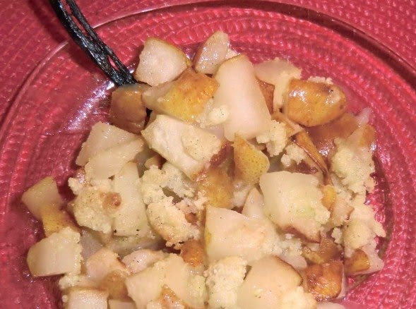
Pear crumble with almonds

Pear crumble with almonds


This warming and tasty dessert is perfect for dark and cold winter evenings. It is super-quick and easy to make.

For this dessert I prefer Williams pears. Wash the pears well, but do not peel them. Most of those important antioxidants are just underneath the skin and you do not want to peel them away.

In France you can buy poudre d’amande in ordinary supermarkets. Poudre d’amande could be translated as almond flour, and is used a lot in French pastries. Elsewhere you usually have to grind the almonds yourself into flour.

2 servings

2 Williams pears
1 tbsp rapeseed oil

For the crumble:

1 heaped tbsp sugar
1 heaped tbsp almond flour, poudre d’amande
1 heaped tbsp flour
2 tbsp rapeseed oil
½ vanilla pod

Wash the pears well and cut into small cubes. In a frying pan, warm 1 tbsp rapeseed oil over medium- high heat and quickly sauté the pear cubes. Line a smallish ovenproof dish with baking paper and pour the pear cubes in it.

Preheat the oven to 210⁰ C.

In a bowl mix the sugar, flour and almond flour. Cut a half vanilla pod length-wise and scrape the seeds into the sugar- flour mixture. Mix well, and then add 2 tbsp rapeseed oil and mix into a paste. Scatter this on top of the pear cubes.

Bake in oven for 15 minutes until golden. Serve the crumble warm. Vanilla ice cream would go nicely with the crumble.


0 comments:

Note: only a member of this blog may post a comment.

From Peille to Cime de Baudon

View to north from Cime de Baudon

Upper parts of Peille with Cime de Baudon in background

Starting point in Peille for Cime de Baudon

Today’s ascent to Cime de Baudon (1264 m) starts from the hillside village of Peille (650m) about 25 km by road from Nice. The villages of St Agnes and Gorbio are also possible starting points. We have previously hiked to Cime de Baudon from Gorbio. Today’s ascent is shorter and the vertical climb only 620 m versus 900+ m from Gorbio.

Ascending in a pine forest to Cime de Baudon


Park your car in the upper part of the village. The trail starts as the stairs of St Bernhard and continues as a small road called Barri to Col St Berhard (750 m; 15 min walk from the village). From this point turn right and ascend along a path in a beautiful pine forest. Follow closely the yellow signs (which are numerous on this route) and signposts. The path reaches a plateau with a signpost at 974 m. From here, the ascent is steeper and requires some easy
The plateau before the final steep climb to Cime de Baudon
scrambling when climbing the southern slope before the summit.


On the mountaintop, there is a table d’orientation and a 360 degree panoramic view. Thanks to the clear January weather, we were even able to see Corsica. It has been said to be just refraction due to atmospheric factors. However, if the atmosphere is not taken into account we calculated that from the altitude of 1000m a mountain range of 2000m (Corsica’s highest peak Monte Cinto is 2706 m) should be well visible given that the distance to northern Corsica is about 190 km.
Easy scramble before reaching the summit of Cime de Baudon


Looking north, you can see the snow capped peaks of the southernmost Alps. Not surprisingly there were quite a few hikers enjoying the views on this winter day. Cime de Baudon certainly is one of the most appealing mountains near the Riviera. The summit is just 7 km from Monaco coastline as a crow flies and yet you are in the middle of the nature.  There’s a feeling of a real mountain. No ancient bunkers or masts spoil the scenery.
Corsica just visible above the haze


The descent is first along the same trail but then continues along the mountain ridge further west before descending steeply back to the same trail that was used on the way up.

Duration:         3 h 45

Vertical climb: 620 m
Descending back to Peille along the ridge


Map: IGN Nice Menton Côte d’Azur 3742 OT


The Randoxygène guide has a description of this hike in French

0 comments:

Note: only a member of this blog may post a comment.