Lac de l'Etoile from Col de Vars

Lac de l'Etoile Vars


Having previously hiked to Paneyron (2785 m) from Col de Vars, we now wanted to explore the trail which continued further northeast from the summit. Our goal was Lac de l’Etoile (2755 m).

It was a gorgeous July morning. We had to drive up to Col de Vars (2108 m) early as the road was to be closed later in the morning because of a cycling event.


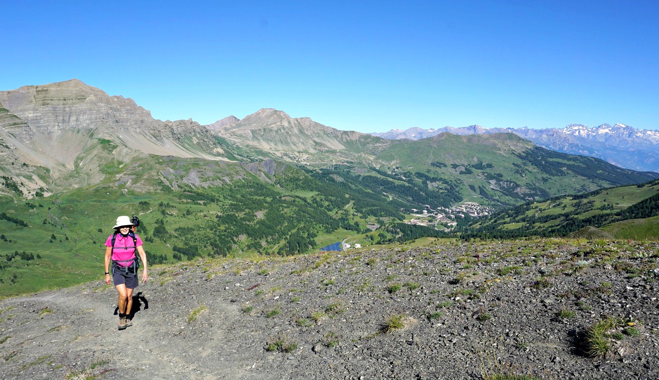
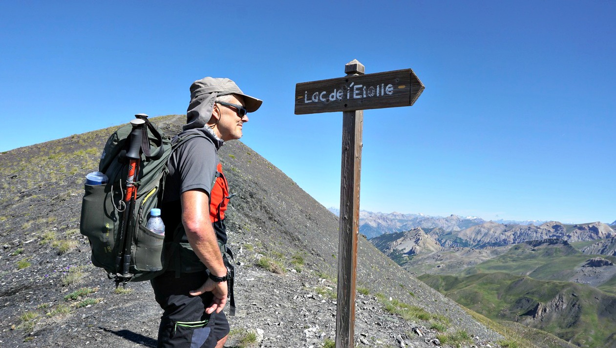
From Col de Vars, we took the dirt road which went to a shepherd’s hut. The trail to the summit forked right just before it, and we started to ascend along the southwestern flank of Paneyron.  The trail first passed Alpine meadows, but soon the landscape became rockier and arid. Next to the summit, we came to a signpost showing Lac de l’Etoile to the right (east). After a rapid detour to the summit, we followed the trail which soon descended quite steeply. We had to focus on every step as there were loose stones and gravel. But we later found out that this path was one of the trail runners’ itinerary!

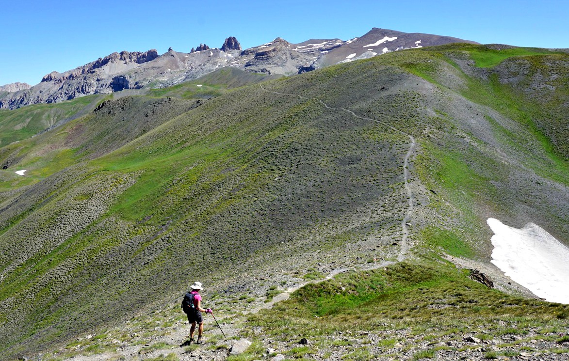
After the descent we ascended from 2655 m to 2731 m, followed by several smaller climbs and descents which increased our cumulative climb. The trail itself was easy to see, there were cairns and sporadic fading yellow markings.

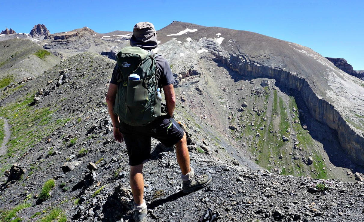
We passed an unnamed lake. We had simultaneous views to the Les Ecrins massif, Aguille de Chambeyron in the east and above all, the imposing massif in front of us: la Mortice, Pics des Houerts and many other 3000 m+ summits.

The shores of Lac de l’Etoile were still partly covered with snow. The lake lies in dark flysch terrain (shale/sandstone). Other geological wonders nearby include the huge karst formation below La Mortice, the highest in Europe.

We headed back along the same trail. Just before Col de Vars, we took the path which circled the hill between the Col and the hut (map below).

Climb: 1024 m

Distance: 13 km

Duration: 5h 30

IGN Map: 3538 ET « Aguille de Chambeyron Cols de Larche et de Vars »


Lac de l'Etoile track


Lemon ricotta with strawberries

Lemon ricotta with strawberries


What a delight it is to find the first tasty local spring strawberries! And nowadays we can buy them organic. For dessert, strawberries are usually served with sweetened whipped cream.

For a change, try serving them with ricotta mixed with lemon juice. It is important to use original Italian ricotta in the recipe because “ricottas” made in some other countries just don’t have the desired consistency and don’t mix so easily with lemon juice. Great taste but less calories and no added sugar.

2 servings

About 2 handfuls of local organic strawberries
150 g Italian ricotta
Juice of ½ small lemon

Wash the strawberries under running water and let dry on kitchen paper.

In a bowl, whip the ricotta and lemon juice with a spoon. Divide into 2 dessert bowls.

Slice the strawberries and divide on top of the ricotta. Enjoy!

Mont Brune between Esteron and Var River Valleys

Viewing Mercantour summits from Mont Brune


 At 1518 m, Mont Brune is the second highest peak in the mountain ridge dividing the Esteron and Var River Valleys. We have previously hiked to the highest, Mont Vial (1550 m) as well as to Cime de Collettes (1513 m).

The mountains here, south of the Var River are Castellane Prealps. This particular summit seems to be much less visited. The easiest way to explore this peak is to start from Col de Vé Gautier by the narrow and sinuous D27 road 5 km west of Toudon


View from Col de Vé Gautier
 
Path from forest road to Mont Brune
 
Path after signpost#96
 
View towards Ascros
We found a good parking by the D27 road, just opposite the forest trail that actually zigzags all the way to a clearing under Mont Brune. The hiking trail crosses this dirt track several times and sometimes follows it.


We started to ascend along the forest trail from D27 road and located the hiking trail after the second bend where we forked right. This part of the trail was a narrow, sometimes overgrown path and yellow markings were sporadic. We reached signpost #96, and followed its instructions. Now heading northwest along Mont Brune’s southern flank, the trail became a little wider and easier to follow.


Shortcut to Baisse du Mont Brune
 
Cime de Collettes and Mont Vial
 
On the trail to Mont Brune
 
Var River seen from Mont Brune
At signpost #95, we turned sharply to the east, and climbed to signpost #94 by the dirt road, which we followed about 150 m before making a shortcut again. We climbed along a narrow path, quite steeply for about 30 m. The trail then levelled off and came back to the dirt road a little before signpost #93 at Baisse du Mont Brune. Here, at a clearing, water reservoir and helipad we took the final leg to the summit. Parts of the trail were steep and in places the vegetation was dense. Just before the summit the trail made a 90° turn west (a cairn). We then climbed, sometimes off-piste, to the top of Mont Brune.

 
View from Mont Brune eastern flank
 
Easy scramble before Mont Brune summit
 
Summit of Mont Brune
The summit itself was marked with a bigger cairn and a stick. The panorama was perfect. We descended back to Baisse du Mont Brune and then took the forest road down to D27 road for a change.

Climb: 430 m

Distance: 7,7 km

Duration: 3h 10 active

Map: IGN Vallée de l’Esteron Vallée du Loup 3642 ET

Mont Brune hike track


Zucchini blossoms stuffed with ricotta, parmesan and black olives


It is a true sign of summer when zucchini flowers, fleurs des courgettes, appear in our supermarket in Nice

The following lacto- vegetarian recipe reflects the Italian influence in the Niçois cuisine. Serve this dish with a heap of cherry tomatoes and some good bread for a healthy and carefree lunch.

2 servings

8 zucchini blossoms
150 g ricotta
4 tbsp. black olives, pitted and sliced
A handful of grated parmesan
Olive oil
Freshly ground black pepper
12- 16 cherry tomatoes, chopped
1 spring onion, finely sliced
Basil leaves to decorate

Warm the oven to 200° C.

Mix the ricotta with parmesan, black pepper, 2 tbsp. olive oil, and half of the sliced olives.

Wash the zucchini blossoms and let dry on kitchen paper. Spread some olive oil in the bottom of a large oven- proof dish. Stuff the zucchini blossoms with about 1 tbsp. of the ricotta mixture per each blossom and fold the rest of the blossoms to make a small pocket. Place them on the oven-proof dish and sprinkle with 2 tbsp. olive oil. Cook in the oven for 7 minutes.

To make the cherry tomato salad, wash and dry the tomatoes, then chop them and let drain in colander for a while to remove the extra liquid. Mix the tomatoes with the sliced spring onion, the rest of the sliced olives, some black pepper and 1 tbsp. vinaigrette.

Divide the cherry tomato salad in the middle of the plates and place the zucchini blossoms around. Decorate with basil leaves.


Loop trail above Courmes

Viewing Puy de Tourrettes


The village of Courmes (630 m) is about 16 km from the Mediterranean as the crow flies. We have previously made good hikes from the village, such as to the nearby peaks Puy de Tourrettes and Pic de Courmettes, both over 1200 m.
On today’s hike we wanted to explore a new itinerary that also made a loop in the western part of the vast St Barnabé Plateau.

We forked left from the village parking, heading straight north towards Vallon des Combes. The path was marked yellow. Most of the signposts along the trail had old numbers compared with the new IGN hiking map of the area. For example, we started from signpost #88 which was #250 on the map.


The first stretch offered great views of the Loup River Valley. We ascended further in the woods through Vallon des Combes, came above the tree line to signpost #87a (256 on the map!), and forked left and descended a bit to a clearing named Pré Royer, where the next crossroads signpost#258 in fact had the same number as on the map. We crossed some meadows and an abandoned hut, and came to a dirt track. We turned right; now  heading northeast. At the crossroads there was a signpost placed on a rock with an unofficial signpost with names irrelevant for our planned itinerary. We were still guided by yellow markings, and climbed to little over 1000 m elevation, passing signpost #153 (map # 265), where the trail turned southeast towards St-Barnabé.

We followed the trail to the next crossroads, marked with #155 (on the map #264), showing the trail back to Courmes. Numerous other trails crisscross the St-Barnabé Plateau. We came to an oratory by the path, and descended back to signpost #87a. From this point, we took the same trail back to Courmes.
Our GPS track is shown below; signpost numbers are those on the map.

Elevation gain: 470 m

Distance: 12,3 km

Duration: 3h 35

Map: 3642 ET Vallée de l’Estéron Vallée du Loup


Saint-Barnabé loop hike track

Veal roast Mediterranean style

Veal roast Mediterranean style
Veal roast Mediterranean style 


French veal roast, rôti de veau, is tied together and surrounded by thin lard slices. These can be removed after the roast is sliced or everybody can simply remove them on their plates while eating. The latter is often the case in small French restaurants.

If you make the roast for 2 people and there are leftovers, you can make the classic Italian Vitello tonnato next day.

4 servings

About 600- 700 g veal roast, roti de veau
2 tbsp. pine nuts
1 tbsp. black olives
1 tbsp. capers or 6 large Italian capers
Olive oil
Black pepper
1 tsp. dried Provençal herbs
150 ml chicken stock
150 ml white wine
Fresh herbs

In a large heavy frying pan, brown the roast in olive oil on both sides. Preheat the oven to 200° C, roast.

Transfer the veal to a baking dish and add the pine nuts, olives, capers, black pepper and dried Provençal herbs around the meat. Pour in the chicken stock and white wine.

Roast in 200° C for 30 minutes. Then lower the temperature to 180° C and continue cooking for 20 minutes. Transfer the veal to a cutting board and slice. Divide the slices on the plates and spoon over the pine nut-olive sauce from the roasting dish.

Serve the veal with lentils and vegetables of your choice. Decorate with fresh herbs.


Mont Arpasse

Viewing Mont Vial from Mont Arpasse


Viewing Mont Arpasse from nearby Levens, it looks more like a hill. But don’t let that impression and the elevation (695 m) deceive you! Situated above the confluence of Var and Vesubie Rivers, you have exceptional views down to both river valleys as well as the to the coast, the nearby mountains (such as Mont Vial) and of course the Mercantour peaks further away.

The village of Levens has a distinguished past; it is the birthplace of the first French mayor of Nice Francois Malaussèna and Napoleon’s Marshal André Massena spent his childhood here.

We drove to Levens along the sinuous M20 road, passing the village of Roquette-sur-Var. We turned left to Avenue Charles David, and after a few hundred meters again left to Chemin de la Môle, passing the fire station then parked soon afterwards on the right-hand side of the street. The trailhead with signpost #293 was just 100 m away.


We first ascended briefly along a wide and partly cobbled trail before descending to Vallon de l’Alborée where we crossed a small stream. We then began to climb again reaching signpost #294. There was a gate and a notice of sheep flocks. We continued south, following the trail marked yellow (and not the dirt track that also climbed up to the summit), and reached the mountaintop after about 1h 10. It was marked with signpost #295 (title picture above). We saw a sheep flock far away south of the summit, so no worries; we could make the tour as planned.

From the summit, we continued northwest then north, descending rapidly. The trail was still very good but became a bit rocky and steeper before signpost #296 so here it was good to have both good hiking shoes and poles. The trail ran under several power lines. In spite of them, we had perfect views all the time. The western flank of the mountain above Plan du Var was precipitous. At #296, we forked right to Ravin de l’Arpasse and ascended to signpost #294, completing the loop.

All signposts are visible in the map below.

Duration: 2h 45 hiking time

Distance: 7,5 km

Elevation gain: 370 m

Map: Vallée de la Bévéra TOP 25 N°o 3741 ET

Mont Arpasse trail track