Mercantour: The trail over Pas de l'Arpette
This alpine hike from the Gordolasque Valley over Pas de l’Arpette (2511 m) inside Mercantour National Park also offers a direct access to the mythic Merveilles Valley. The Merveilles Valley is famous for its prehistoric engravings. These are now protected, and you have to stay strictly on the path when visiting this valley.
Mont Bego (2872 m) situated east of the Merveilles Valley is known to attract thunderstorms. The prehistoric inhabitants considered this mountain sacred, and the rock engravings testify of its importance.
The hike starts from the Pont du Countet (1690 m) where the narrow paved road ascending in the Gordolasque Valley ends. The distance from Nice is 66 km by road, and the Mediterranean coast is just 32 km away as the crow flies. Pont du Countet is also an important starting point for other hikes in high terrain, such as the one going to Refuge de Nice.
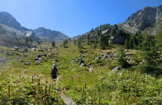
From the parking, walk over the bridge where you find signpost # 412: Pas de l’Arpette 3 h and Merveilles 4 h. The trail (marked with yellow signs) starts to ascend steeply in the woods comprising mainly larches and Cembra (or Swiss) pines. Once over 2000 m, the trees disappear, and the scenery becomes more and more alpine. The trail levels off –but only temporarily. You have a good chance of spotting chamois, perhaps because this trail is less visited.
The last push to Col de l’Arpette is again steeper but the trail is good. We reached the mountain pass in 2h 15 keeping just a moderate pace. On the day of our hike, the weather was perfect and the views were stunning. From the mountain pass, the Lac Long further down can be seen, as well as Refuge des Merveilles on its shore. For an overnight stay, the refuge offers simple accommodation and meals.
The trail winds down towards the lake. The upper part of the slope comprises alpine meadows, whereas further down the terrain becomes rockier again. The vertical descent to the lake is about 400 m. A little before the lake, there’s the main crossroads where the GR52 trail forks left (north) and enters the Valley of Merveilles proper. For most of us, exploring this trail would require another day.
We returned along the same trail to Pont du Countet.
Total hiking time: 6h 30
Vertical climb: about 1200 m
Description in French: (the Randoxygène guide)
Map: IGN Vallée de la Vésubie 3741 OT
Image of itinerary courtesy of Google Maps


0 comments:
Note: only a member of this blog may post a comment.