|
Montagne de Thiey in autumn
|
We have previously made this great hike to Montagne de Thiey (1553 m) in the Côte d’Azur Prealps some years ago in early autumn. Now, in spring, the scenery could not be more different, with the nascent greenery of the various vegetation zones. Near the summit, we saw wild peonies and, when returning, we walked through a beautiful beech forest.
 |
| Start from Nans parking |
 |
| Forest above Nans Valley |
 |
| Southern flank of Montagne de Thiey |
The access from the coast is easy as the parking by the Nans Valley is next to the RD85 road (19 km from Grasse).
The itinerary from the parking (860 m) was easy to follow as the signposts and markings (yellow) were numerous. We ascended both along dirt tracks and good trails (signposts #65, 66, 67, 68, 69, 70 and 71). There were some steeper stretches just before the summit. Even on a hazy albeit clear day we had great 360° views, from the snow-capped Mercantour peaks to the Esterel coastal mountains.
We returned to signpost #69, then headed northeast under Crête de Thiey. We descended, quite steeply in places, to a beech forest at about 1000 m elevation where we forked right at signpost #178. After a brief ascent we descended continuously to the verdant Nans Valley, passing signposts #72 and 127. The stream in the valley was completely dry. There had been only sporadic rainy days since the beginning of the year. We passed signpost #66 before reaching our starting point.
Most hikers seemed to return along the same trail. We warmly recommend the loop on the way back.
 |
| Nans Valley and Colle du Maçon |
 |
| Signpost#69 return trail crossroads |
 |
| Barres de Thiey |
 |
| Near Montagne de Thiey summit |
 |
| Montagne de Thiey summit |
 |
| Wild peony by the trail |
 |
| Crete de Thiey southeastern flank |
 |
| Beech forest by the trail back |
Map: “Haute Signe” 3543 ET
 |
| Veal escalopes stuffed with Parma ham |
This classic Italian dish gets a different twist if you use basil leaves instead of sage leaves and add some good tomato sauce to the white wine sauce. Whole wheat pasta with parmesan and steamed green beans go well with the veal.
2 servings
2 thin veal escalopes, about 120- 150 g each
2 slices of Parma ham
4 basil leaves
2 tbsp. olive oil
Some wheat flour for dusting
150 ml white wine
2 tbsp. tomato sauce
Freshly ground black pepper
Place the escalopes between two sheets of aluminium foil and pound with your fist to make them thinner. Grind over some black pepper and place a slice of Parma ham on each escalope, followed by basil leaves. Fold over the escalopes to make a pocket and secure with a cocktail stick. Lightly dust both sides of the escalopes with flour.
Warm 2 tbsp. olive oil over medium- high heat in a frying pan. Cook the escalopes 2- 3 minutes on both sides until golden brown. Add the wine, tomato sauce, and some more black pepper. Increase the heat to high and let bubble until reduced by about half.
Drain the cooked pasta, divide on the plates and fold in some parmesan. Divide the escalopes surrounded with the sauce and steamed green beans on the plates.
 |
| Beachfront near Trayas station |
The Esterel Coastal Massif located both in Var and Alpes Maritimes Departments is of volcanic origin. The rock consists mostly of rhyolite, giving the hills a distinct red colour.
Numerous roads, some of them paved, crisscross the region. But there is a network of hiking and mountain biking trails as well, and some of them cross surprisingly rugged and sauvage terrain. The landscape is quite different from what you see elsewhere in Alpes-Maritimes.
We decided to hike up to Pic de l’Ours (496 m), starting from the parking by the D559 coastal road, near the Trayas train station. Another option is to use the small parking next to the station.
 |
| Trail behind Trayas station |
 |
| Rocky trail above Le Trayas |
 |
| Le Trayas coast |
 |
| Pic de l'Ours |
We walked up to the starting point behind the station (300 m), carefully crossing the road and the railway. We forked left and followed a wide dirt track about 370 m, then forked right and ascended along a rocky trail about 400 m before reaching a crossroads. We forked sharply right (if you miss this, you end up doing the hike clockwise!) now along a yellow-marked trail. We climbed, partly in the woods, to Col de Notre-Dame (324 m).
We now had Pic de l’Ours above us, and chose the direct route up to the summit. The trail (blue markings) was quite steep in places. The summit itself was a restricted area, with a large white/red mast and different other telecom antennas. The spring day was warm but a bit hazy. We had nevertheless great views towards Cannes and beyond in the east and Frejus in the west.
 |
| Cannes seen from Pic de l'Ours |
 |
| Dent de l'Ours |
 |
| Pic du Cap Roux |
 |
| Path under Pic de l'Ours summit |
After a picnic break, we continued along a yellow-marked trail which first circled under the summit then descended rapidly to Dent de l’Ours. Our trail continued to the south, then west making a large loop in the rugged terrain before turning southeast to Col de Lentisques. We then followed the yellow trail which descended above Ravine de Cazal de Beuf, where we passed the crossroads on the way up, then back to or starting point.
The trails of this hike were good but very rocky. Good hiking shoes and poles are essential. It can be very hot during the summer months. Compared with Alpes-Maritimes, there are just sporadic signposts but the itinerary is well colour-marked and easy to follow. Study the itinerary on the map (digital or paper) before leaving.
Duration: about 3h 45 active
Map: 3544ET Fréjus St-Raphaël Corniche de l’Esterel
Spinach is a popular vegetable in all Mediterranean countries. I remember a trip to Rome one autumn when almost all small restaurants served only boiled spinach as a vegetable side.
Spinach is said to have originated somewhere in Persia, and was brought into the Mediterranean countries by the Arabs. The following recipe with pine nuts and golden raisins suggests an Arab origin. This vegetable side goes very well with roasted mackerel fillets and panisses, South of France chick pea cakes.
2 servings
About 4 handfuls of baby salad leaves
2 tbsp. golden raisins
2 tbsp. pine nuts
1 tbsp. olive oil
2 shallots, chopped
1 clove garlic, minced
Freshly ground black pepper
Warm the olive oil in a large saucepan over medium- low heat and start sautéing the golden raisins and pine nuts. Add the shallots and garlic and continue sautéing for 10 minutes until soft.
Wash and dry the spinach leaves and add to the saucepan. Raise the heat to medium and sauté for about 5- 10 minutes until the spinach is wilted.
Serve with roasted mackerel fillets and panisses.
Today’s hike features a loop above Vence, starting from the popular Plan des Noves parking (780 m) by the D2 road. Having hiked here many times, we now wanted to try a new itinerary, first using tracks and trails west of the D2 road.
 |
| Track leaving GR51 |
 |
| Mouton d'Anou |
 |
| Oratory |
 |
| Puy de Naouri and Tourrettes |
We crossed the road and headed west along the GR51 (images 1 and 3 ) as far as to signpost #136 where we forked left (2 ), leaving the GR trail (and marked hiking trails). We followed a wide track mainly to the south, passing an oratory (4 ). We made a short detour to a hilltop (839 m) at Jas de Bayle with great views to the west, notably to Puy de Naouri and Puy de Tourrettes (5 ). We continued along the dirt track (no markings but easy to follow) further south, then to the east (6 ). Near Colle Bertrand we forked left (7 ) and followed a narrower trail which passed a solitary oak tree, then descended in a northerly direction towards the D2 road.
We soon reached the road, forked right and descended along it (carefully in a single line) about 500 m to signpost #130 (581 m), where we followed the trail up to Mangia Pan (699 m; signpost #131; image 8 ).
We headed straight north to signpost #133 (at 678 m; marked as Plan des Noves) where we re-joined the GR51 trail and followed it back to our starting point.
 |
| Baou des Blancs and Vence |
 |
| Crossroads near Colle Bertrand |
 |
| Mangia Pan |
It turned out to be a nice loop variant along easy trails. Only the trail descending back to the RD2 road was narrow in places and might become a bit overgrown in summer.
Map: «Cannes-Grasse» Côte d’Azur No 3643 ET or Vallée de l’Estéron Vallée du Loup 3642 ET
 |
| Loop from Plan des Noves parking |
This is a recipe for summer and autumn when local cherry tomatoes and basil are in season. Serve it with black rice to further compliment the colours of different cherry tomatoes.
2 servings
2 organic chicken breasts
About 2 handfuls of organic cherry tomatoes, a mixture of red and yellow
1 shallot, chopped
1 clove garlic, minced
150 ml white wine
1/3 cube of chicken stock
About a handful of organic basil leaves
Olive oil
Freshly ground black pepper
Warm 2 tbsp. olive oil in a frying pan over medium heat. Sauté the chicken breasts for 5 minutes until golden. Turn the chicken breasts and add the shallot and garlic to the pan. Continue sautéing for 5 minutes.
Wash the cherry tomatoes and basil leaves and let dry on kitchen paper. Add the cherry tomatoes, white wine, and the crumbled stock to the pan. Cover and let simmer for 10 minutes.
Chop the basil leaves. Add most of the leaves to the pan, saving some for decoration. Reduce the heat and let simmer for 3- 5 minutes uncovered. Grind over some black pepper and divide on the plates.
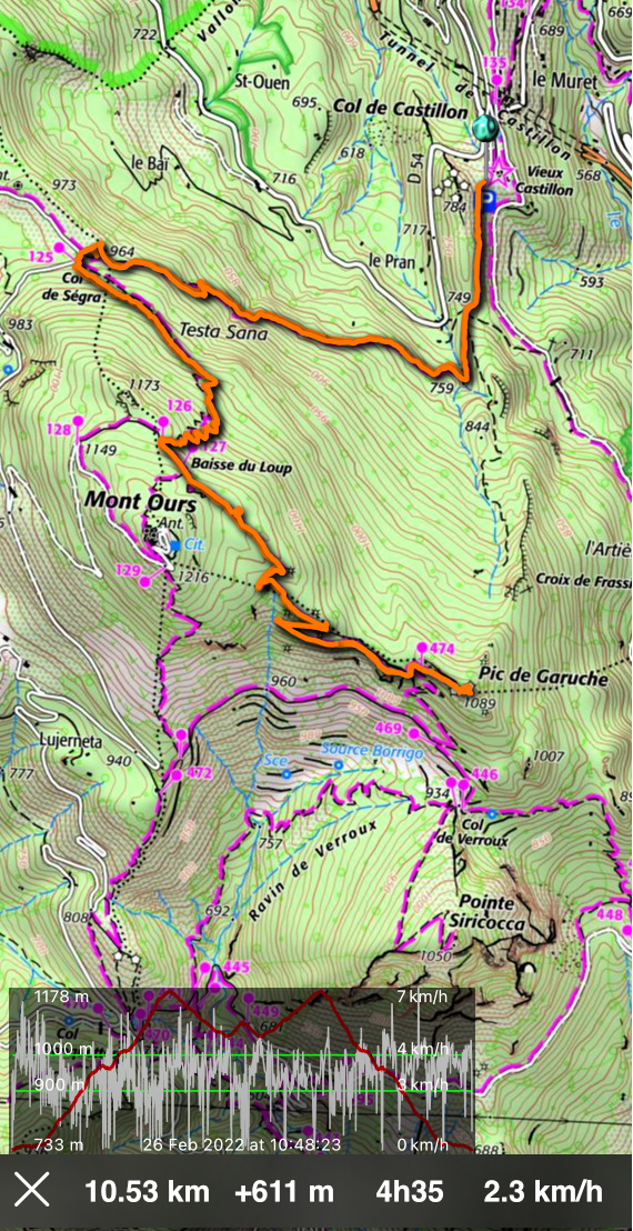
Pic de Garuche (1089 m) above St Agnès is one of the many mountains where Maginot Line fortifications were built in the 1930s. Situated southeast of Mont Ours (1236 m), an artillery observation post was erected there. Having hiked to both Mont Ours and nearby Pointe Siricocca (1050 m) before, we had not explored this peak before.
On a clear and crispy winter day, we decided to ascend there from Col de Castillon parking (730m) along the trail which passes near the summit of Mont Ours. Another good option is to start from St Agnès (600 m) or Col des Banquettes (736 m).
 |
| Trail start from Old Castillon |
 |
| Trail to Col de Ségra |
 |
Mercantour peaks
|
From the parking, we first headed south, then west ascending along the forested north-eastern flank of Mont Ours to Col de Ségra (963 m); signpost #125. At the col, we forked left (southeast) and climbed to signposts #126 and 127, the latter at Baisse de Loup (1171 m) just under the summit of Mont Ours. We continued straight (Col Verroux, Ste Agnès) along a wide apparently ex-military trail.
 |
| Mont Razet and Grammondo |
 |
| Near Baisse du Loup |
 |
| Col Verroux |
 |
| Military trail to Pic de Garuche |
 |
| Menton coastline |
 |
| Pic de Garuche summit |
We descended along it to a crossroads and signpost #474 under Pic de Garuche and climbed to the summit. Being an ancient observation post, we had great views towards the coast at Menton (only 6,5 km away) as well as the snow-capped Mercantour peaks.
We returned along the same trail.
Duration: Active hiking time about 4 h
Map: Nice Menton Côte d’Azur 3742 OT
This protein-rich vegetarian dish is made with spices that are typical in different Mediterranean countries. Ras el hanout is a Moroccan spice mixture of ground black pepper, ginger, mustard grain, cinnamon, muscat, hot pepper, and sweet bell pepper. Piment d’Espelette is a fairly hot ground chilli pepper from the Espelette village in the Basque Country. Saffron threads came with the Arabs to Spain and are now widely used in the Mediterranean countries.
This spicy dish makes a perfect heart-healthy lunch.
2 servings
2 medium size sweet potatoes
Olive oil
120 ml green lentils
2 shallots, chopped
1 clove garlic, minced
1 medium tomato, finely chopped
1 tbsp. rase el hanout
0,5-1 tsp. Piment d’Espelette, depending how hot you want it
1 dose saffron threads
2 tbsp. tomato purée
200 ml organic passata, Italian tomato sauce
Fresh mint leaves, chopped
Preheat the oven to 200° C roast.
Peel and halve the sweet potatoes. Brush them with olive oil and roast for 25- 30 minutes until soft.
Meanwhile cook the green lentils in a saucepan for about 30 minutes until soft.
Heat 2 tbsp. olive oil in a large frying pan over medium heat. Sauté the shallot and garlic for 5- 10 minutes. Add the chopped tomato, spices, passata, and tomato purée. Reduce the heat to simmering.
When the lentils are cooked, drain any water remaining in the saucepan and add the lentils in the frying pan. Stir and keep simmering.
When the sweet potato halves are soft, divide them on the plates. Divide the lentil- passata suce on top and decorate with chopped mint.
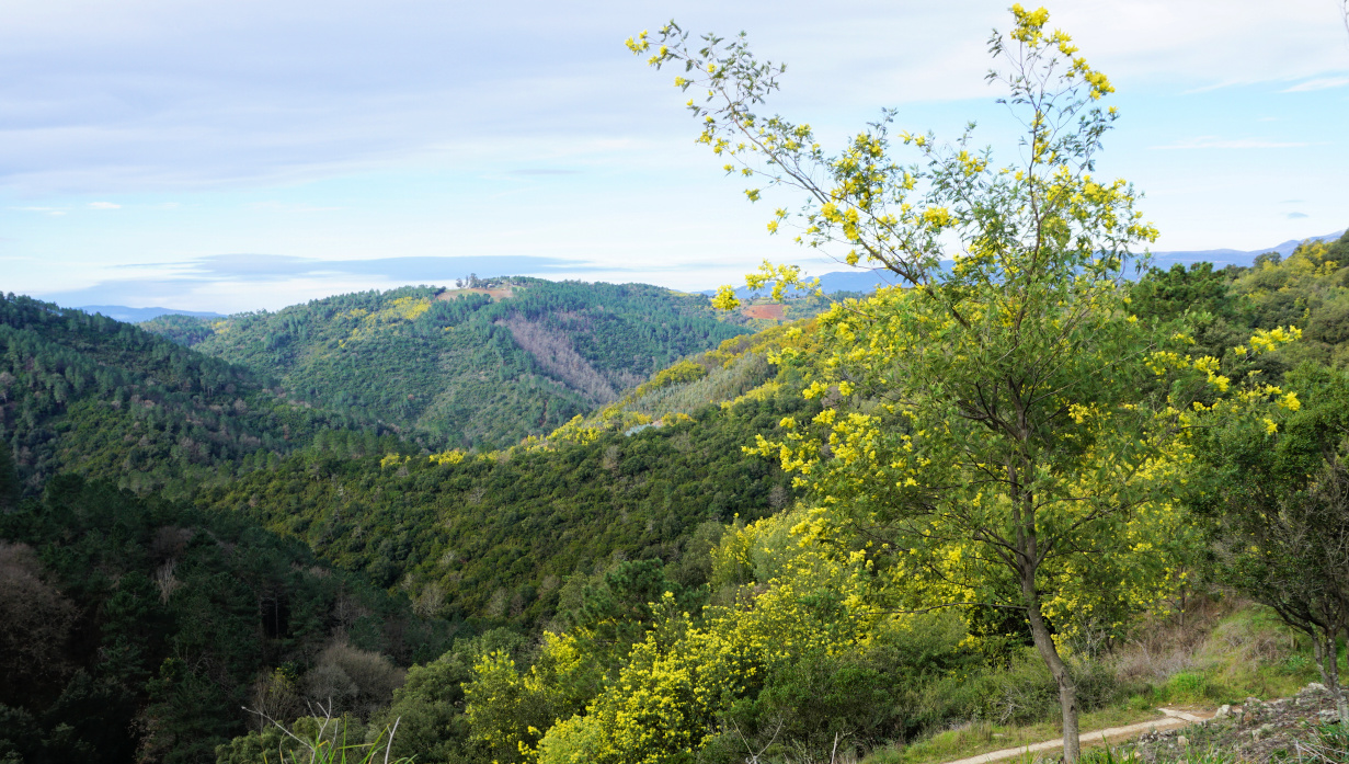
The village of Tanneron (~400 m elev.) has become the unofficial capital of the mimosa. From January to March, the mimosa colours yellow the hill flanks above Mandelieu-la-Napoule. Not part of the original flora, the mimosa tree was originally imported from Australia and thrives in Côte d’Azur.
Several families in Tanneron now cultivate mimosa and export flowers to all France and beyond. Numerous varieties of the mimosa exist which explains the long flowering season.
Lots of visitors come to the small village to admire the yellow flowers in mid-winter, and many wish to take advantage of shorter or longer hiking routes in the surrounding hills.
We made the long (16+ km) but very popular Ridge of Tanneron (Circuit Les Crêtes de Tanneron) loop hike on a pleasant February day.


We used the village as our starting point. We descended, using a shortcut passing the fire station to the signpost (pictured) below the village showing the itinerary. Once deep down in the valley, we followed the Aubarie stream, crossing it a few times.
We came to a bend by the D38 road at about 150 m elev., walked along the road about 70 m before starting to ascend gradually in the woods, in a southerly direction. Once higher up, the scenery changed and when we reached the ridge there were blossoming mimosa trees by the trail in abundance. We had unobstructed views to Grasse and beyond. We passed some mimosa cultivations and came to the neighbourhood of les Farinas (about 470 m elev.) with some nice properties. Here, we continued along a paved road (Chemin des Farinas), heading mostly east. The yellow-marked trail follows the road. We took a 700 m detour near les Grailles along a nice unmarked trail, and re-joined the paved road after a steep descent.


We descended further along the road to a crossroads where we forked left and followed a wide DFCI dirt track as far as to Vallon de la Verrerie where we again forked left (west). After about one km we crossed the stream in the valley and climbed back to Tanneron, first passing a parking at Touordam, next to the tennis courts.
Duration: 4h40 active walking time
Map: 3543 ET Haute Siagne
Some time ago, we had a delightful lunch on the terrace of an Italian restaurant in Merrick Park, Coral Gables. The fish was a prized South Floridian red snapper, lightly flowered and pan-fried. It was served on an olive oil-tomato-caper sauce with potato gratin, Gratin Dauphinois, and green beans. The dish was colourful and traditionally Italian.
My recipe is inspired by this lunch. I use fillets of cod, breaded and oven-roasted. The sauce is traditional French sauce vierge with added capers. For the recipe, you could use any fresh tasty white fish fillets such as cod, monkfish, sea bass and so on.
2 servings
2 pieces of cod fillet, about 120 g each
2 tbsp. bread crumbs
Olive oil
For the sauce vierge:
50 ml tasty organic extra virgin olive oil
Juice of ¼ lemon
A dash of pressed garlic
Freshly ground black pepper
1 ripe medium tomato
2 tsp. small capers
Chopped basil or parsley
Preheat the oven to 200°C, roast.
Chop the tomato into very small pieces and place in a bowl. Add the olive oil, lemon juice, pressed garlic, black pepper, and capers and mix. Let the tomato marinate while you prepare the fish. Just before serving, mix with chopped fresh herbs.
Coat an oven-proof dish with olive oil and pace the fish fillets in it. Cover the fillets with breadcrumbs and drizzle over some olive oil. Roast for about 10 minutes, depending on the thickness of the fillets.
When the fish is done, divide the sauce vierge on the plates and place the fish on top. Serve with potato gratin and microwaved green beans.