In spite of its modest elevation, Mouton d’Anou (1079 m), is a dominating summit on a large plain behind the Baous of St-Jeannet and La Gaude.
We have previously tried to hike to Mouton d’Anou from Saint-Jeannet some years ago, but had to turn around at Jas Jausserand because a sheep flock guarded by several large dogs was staying in the middle of the trail, and making a detour was not possible.
This time we decided to start our ascent from the perched village of Le Broc (450 m) along a straight-forward trail. As the hunting season was still in full swing, we chose a non-hunting day.
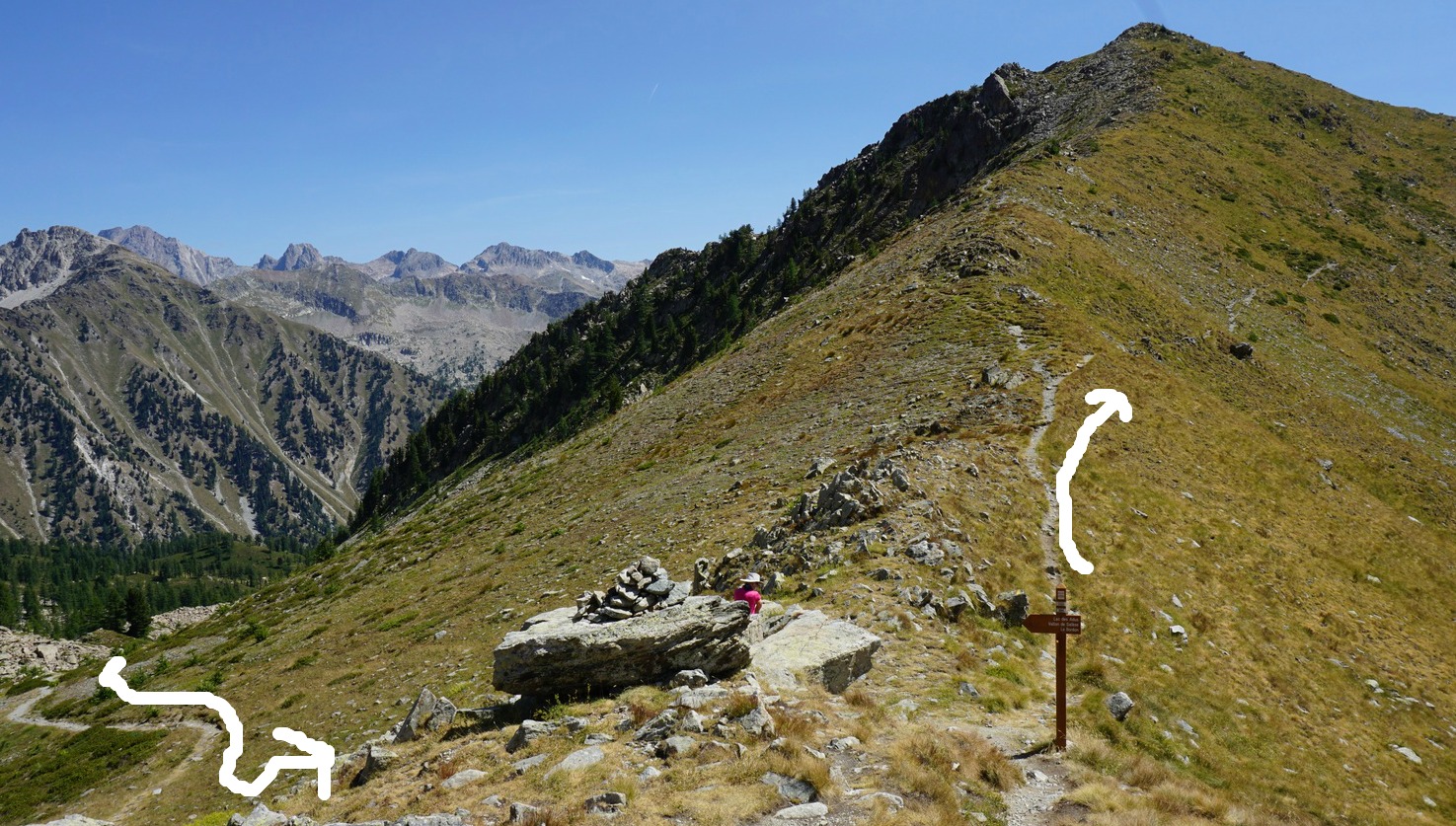
From Le Broc Village, we started from signpost #1 (37 in old maps!) along a steep narrow street. In fact, this and the next signpost (#3) did not have our summit written, only Bouyon, Bézaudun and others. The trail proper soon forked right from the paved alley. The first part was a steep path, but it levelled off soon. We came to a piste, forest road, walked along it a bit till signpost #5 where our trail forked left with Mouton d’Anou clearly shown.
We continued along the trail that climbed gently in a sparse oak forest. We came to another dirt track and signposts #137 and 138. Our mountain was visible. From #138 we took the first apparent trail to the mountain top. The summit was marked with a cross. The view was superb, 360°, from the snow-capped southern Alps to the Mediterranean Sea. We took a parallel path back to the dirt track below the mountain, this trail was less rocky.
We then descended along the same trail back to Le Broc.
Elevation gain : 637 m
Duration : 4 h
Distance : 12,2 km
Map: 3642 ET Vallée de l’Esteron Vallée du Loup

In this recipe, chicken thighs are slowly cooked in tomato sauce with bell peppers. A heavy casserole, cocotte, is perfect for making this carefree but tasty dish.
2 servings
4 free-range chicken thighs with skin
1 red bell pepper
1 green bell pepper
1 shallot
1 clove garlic
2 tbsp. olive oil
75 ml white wine
75 ml chicken stock
3 tbsp. tomato purée
½ tsp. Piment d’Espelette or other mild chilli powder
2 tbsp. black olives
Fresh basil to decorate
Warm the olive oil over medium heat in a heavy casserole such as Le Creuset. Fry the chicken thighs on both sides until golden.
Wash the bell peppers and cut into strips discarding the seeds. Add to the casserole. Peel the shallot, chop and add to the casserole. Peel and mince the garlic clove and add to the casserole.
Add the white wine, tomato purée, chicken stock, and Piment d’Espelette. Reduce the heat to simmering, partly cover the casserole and simmer for 30 minutes.
Add the black olives and continue simmering without cover for 10 minutes. Meanwhile microwave some new potatoes. Divide the potatoes and stew on the plates and decorate with basil.

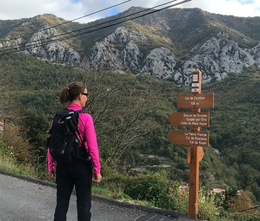
We have previously hiked up to Mont Razet (1285 m) from Col de Castillon (730 m) between Menton and Sospel. This time we decided to explore the trail that circles Mont Razet. The GPS track shows the itinerary. Our planned turning point was the picturesque Col du Razet (1032 m) with views down to Menton and the coast.
Many of the coastal mountains in this region close to the Italian border reach well over 1000 m, notably Grammondo (1379 m). During the hunting season no hunting days, Tuesday or Friday, should be preferred.
We noted that many of the signposts had been renewed. Most of the trail was easy with some short steep and rocky parts. A well-known hiking area for locals, it remains a bit off the beaten track for visitors.
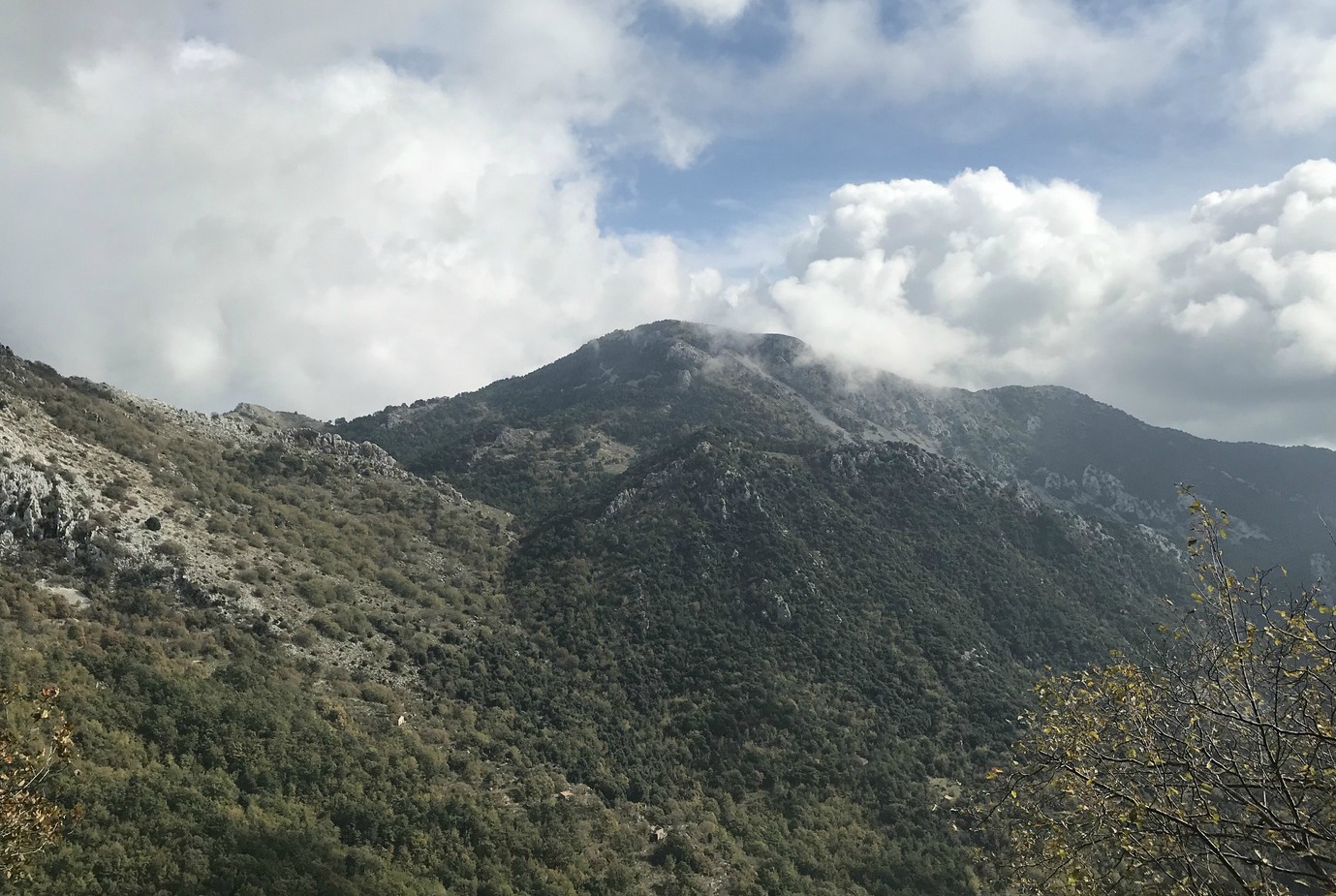
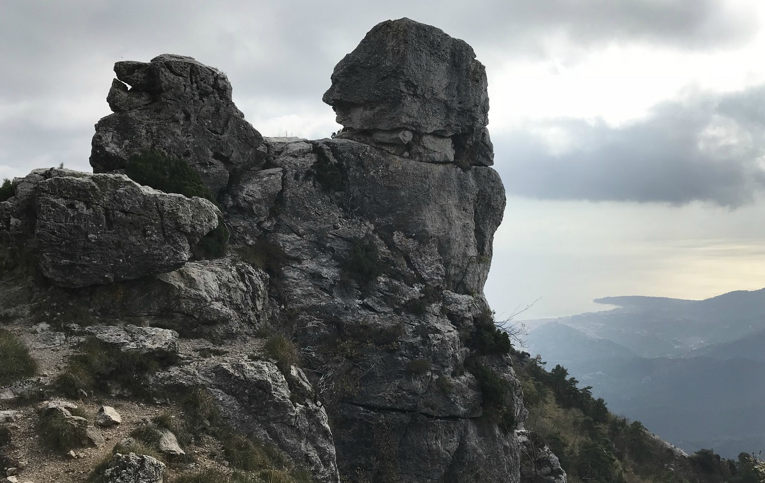
From Col de Castillon we started ascending straight north towards Baisse de Scuvion (1168 m), first passing a crossroads at signpost #137. At Baisse de Scuvion, we were just under Mont Razet. We continued, now descending a bit, heading east to Col de Roulabre (1094 m; signpost #91) then to Col du Razet (signpost #17), where we turned back, followed the same trail to Col de Roulabre (15 min), then further to Pierre Pointue (1176 m; signpost #93 and the crossroads to Mont Razet summit), with remnants of military bunkers by the trail.
After Pierre Pointue the trail descended sharply. Some parts of the trail ran in the forest, some in a rocky incline. Eventually we reached signpost #137 again, and walked back to our starting point.
All in all, it was a great variant of our previous hike where we followed the local randoxygène guide “Circuit du Razet”. In fact, this time we really circled the mountain!
Distance: 9,6 km
Duration: 3h 40
Elevation gain: 616 m
Map: IGN Nice-Menton Côte d’Azur 3742 OT

This vegetable recipe is again loosely based on the French morning TV show Télématin. The presenter first told that the Sun King Louis XIV loved peas so much that he used to eat them as a snack like some other people eat chocolate.
She then presented the following simple but tasty recipe in which peas are cooked together with spring onions, olive oil, and salad leaves. She called this the French way of preparing peas. This green side goes well with simple chicken breast, turkey escalope or, as in our dish, rôti de veau, roasted veal.
2 servings
100 ml frozen peas
2 spring onions, white parts only
2 tbsp. olive oil
A small head of salad leaves, such as a head of little gem
Wash and slice the white parts of the spring onions. In a casserole, sauté the spring onions and peas in olive oil. Wash the salad, chop it and add to the casserole. Cover and let cook for a few minutes.
Stir the vegetables and lift on the plates.

The walk along Canal de la Gravière (about 700 m elev.) above Carros Village (370m) offers great views to Mercantour Summits and the Var River Valley. Local hiking guides call it also Balcon de Carros. We have previously posted hikes in this area: New loop trail above Carros Village and Sommet du Broc.
From Carros Village (370m) we started ascending along the path to Sommet du Broc. The path ends in a forest road; the trail to Sommet du Broc forks left, ascending to Canal de la Gravière where the aqueduct running along the mountain flank became visible. The descending dirt road descends to Le Broc.
This time we wanted to explore the northern part of Canal de la Gravière. A partly ingrown piste followed the aqueduct a few hundred meters after which the water duct dove into rocky and steep terrain, marking our turning point and picnic break.
On the way back, we walked the same way as far as to the crossroads by the forest road. From here we continued along it towards Le Broc. Before Le Broc Village, we reached a wider road and a crossroads showing the direction back to Carros Village, passing the Chapel of St-Sébastien. From the Chapel, the itinerary passed tranquil residential areas, following a paved road.
There were new signposts along the trail. Carros Village is a great starting point for day hikes. By taking advantage of the network of marked itineraries, you can easily tailor make your hike. The image below shows the GPS trail.
Duration: 2h15
Climb: 410 m
Map: 3642 ET Vallée de l’Estéron Vallée du Loup


This vegetable soup recipe is inspired by the French morning TV, Télématin. The presenter first talked about the Sun King Louis XIV, who was very fond of his vegetable garden in Versailles. He was regularly served as a starter vegetable soup made from old-style root vegetables from his garden.
My soup recipe is loosely based on the TV show. The good thing with vegetable soups is that you can easily change the ingredients according to your preferences and seasonal availability.
Serving this soup as a starter is a great way to increase your vegetable intake towards the recommended 3- 5 portions a day. Any leftover soup can be frozen.
Ingredients
2 carrots
2 turnips
2 parsnips
2 Jerusalem artichokes
1 large onion
½ head of cauliflower
3 tbsp. olive oil
800 ml water
1tsp. curry or Piment d’Espelette
Fresh herbs
Warm the olive oil in a large casserole over medium heat. Peel and chop the vegetables, add to the casserole placing the cauliflower on top. Add the curry and water and bring to the boil.
Cover and reduce to medium heat. Cook for 30 minutes.
With a handheld mixer purée the vegetables. Serve in bowls decorated with chopped fresh herbs.

At 2711 m, Mont Saint-Sauveur is the highest peak between the Tinée River Valley and Isola 2000. It offers a great panorama of the surrounding mountains. The view down to the Tinée Valley about 2000 m below is impressive.
The trail from Col de la Valette (2389 m) is alpine, quite stony and in some spots narrow and steep. On the way back, we grew tired of the sharp stones and further down took a parallel ski run/dirt track back to Col de la Valette.
We started from Isola 2000 centre (Front de neige) at signpost #80 well hidden under fir trees. We crossed the valley of Chastillon and walked under a wooden bridge past signpost #81.
The Isola 2000 hiking booklet advises initially to fork left at #81 and to follow Chemin des Italiens, then to climb to signpost #96. We, however, forked right and climbed along ski runs of Pelevos / Mercantour directly to signpost #86 next to the Pelevos Telecabine, saving time and distance. The itinerary then followed easy ski runs as far as to Col de la Valette. From here we continued along a narrow hiking trail that ran in a rocky mountain slope, heading first west, then gradually south.
The summit of Mont St-Sauveur came visible, as well as ruins of old Italian barracks below the summit crest. We reached signpost #89 (2508 m) at the ridge between our goal and Cime de Sistron (2603 m). We forked left and climbed the to the summit. There was a bunker a little below, and another at the mountaintop. High above the Tinée Valley, the mountain had strategic importance as the region used to be Italian territory.
On the way back, we descended a bit more when using the ski runs and dirt tracks, before ascending to Col de la Valette. We therefore recorded about 100 m extra climb (image of GPS track below) .
Vertical gain: 860 m
Duration: About 5 h
Distance: 15 km
Map: IGN 3640 ET Haute Tinée 2 Isola 2000

The Mediterranean sea bass, loup de mer, is nowadays mostly farmed. Wild seabass from Atlantic waters is in France called bar. It takes about 5 years for a wild sea bass to reach the minimum legal length of 42 cm. It then weighs about 900 g and in our supermarket in Nice costs about 33 euros kilo.
For the following simple recipe, I chose a wild line-caught sea bass, bar de ligne. Make sure that the fish is properly descaled and cleaned.
2 servings
1 wild line-caught sea bass, bar de ligne, about 900g
1 fennel
1 organic orange
1 organic lemon
100 ml white wine
2 tbsp olive oil
A pinch of salt
Preheat the oven to 190° C.
Rinse out the belly cavity of the sea bass and dry with kitchen paper. Rub a pinch of salt in the cavity and fill with thin slices of ½ lemon.
Slice the fennel thinly and place in the bottom of an oven-proof dish which is large enough to hold the fish. Finely grate the zest of the orange and add to the fennel. Add the juice of the orange and ½ lemon. Place the fish on top of the fennel and pour the white wine over it. Sprinkle the olive oil on top of the fish.
Bake for 40- 45 minutes until the fish is done. Take a peek inside the fish or make a deep cut to see if it is opaque. Serve with red quinoa or green lentils and a green side salad.

The 15th of August, L’Assomption, is a public holiday in France. We knew that large crowds would head to the mountains as the weather forecast was favourable, and August is the peak season for mountain activities.
To be able to find a parking spot in Le Boréon, we tried to leave early. When we arrived, the Salèse Valley parking was almost full. In addition, we saw that there was a fête patronale in Mollières, now a ghost village on the other side of Col de la Salèse. There was a lot of car traffic apparently heading there as the track that normally is closed had been opened for this event. So, the normally quite tranquil Salèse Valley was very busy that morning!
We had chosen to do a hike “off the beaten track”, first towards Lacs des Adus, then up to Mont Archas (2526 m) via Col de la Valette des Adus (2356 m) as we knew that most hikers would head to Lac Negre, Col de Cerise etc where chamois may be spotted.
We started from signpost #434 at the parking, crossed the stream to signpost 397, and followed the trail that climbed steeply in the woods. We then passed a private refuge and Lacs des Adus. Most of the lakes were dry. We met only sporadic hikers and a few trail runners. We continued the ascent towards Col de la Valette des Adus, now above the tree line. The trail followed the border of the Mercantour National Park. From the col (signpost #394), we continued east along a well-marked trail towards Mont Archas already well visible in front of us. The yellow markings along the trail were new as the route is used by the trail runners.
After a break at the saddle between Cime de la Valette and Mont Archas we were ready for the last 160 m climb to the summit. There were many trails, and we followed the one with yellow markings. The summit itself was marked with a large cairn. The 360° panorama view was quite stunning: Argentera, Cime du Gélas, you name it! The town of Saint-Martin-Vésubie was 1500 m below us.
From the summit, we started the descent heading east, still using the trail runners’ itinerary. The initial descent was steep and rocky along a ridge, so our respect for trail runners increased even more!
Eventually we came to a crossroads at signpost #393 and forked left to Les Adus, the area which we passed in the morning. At signpost #396, a little below the private refuge mentioned above, we closed the loop and headed back to our starting point in the Salèse Valley.
Parts of the trail were rocky and hence more strenuous. The ascent from the valley was more or less continuous. However, navigation was easy as the signposts and marking were new.
Elevation gain: 882 m (Our log)
Distance: 14 km
Duration: 5h 30
Map: 3741 OT Vallée de la Vésubie