The wine-producing village of Séguret is situated west of the Dentelles hills. It is one of the twenty or so Côtes du Rhône Villages that are authorized to use their village name on the label. Wines made under Côtes du Rhône Villages appellation must meet higher standards than those of plain Côte du Rhône. Even higher in the hierarchy are the villages with their own AOC, such as Châteauneuf du Pape, Gigondas and Vacqueyras.
As we had previously tasted some elegant Séguret reds, we now decided to explore the area.
We stayed at Hotel Montmirail near Vacqueyras. The hotel was mentioned for its excellent Provençal restaurant in a 20-year-old guidebook, and we were pleased to find out that that was still the case.
Driving north from Vacqueyras along the D7 road reminded us of Napa Valley. There were numerous wineries and vineyards by the road. At 10 o’clock in the morning, the villages were still very quiet, and many businesses were closed.
Our plan was to visit three very different wineries during the day; A wine cooperative, then a small less known producer, and last an internationally acclaimed producer in the same region.
We started by visiting the Roaix-Séguret cooperative by the D977 road. As the name says, they sell wines produced in these communes. Many of their wines are very attractively priced, too. We tasted their three Séguret reds bottled by the cooperative, namely Domaine Canta Granouio 2013, their blend simply called Seguret Villages 2014, and Roaix 2014, all Appellation Côtes du Rhône Villages Protegée. At 5€ per bottle, they all were good value for money. We chose the Seguret Villages 2014 that we found already now balanced and smooth.
After the first tasting and purchases, we headed to the village of Séguret for lunch. We chose Le Mesclun with a panoramic terrace. Actually there were not that many options in this village or in the vicinity. Their lunch offer called “Petitcuisine du Marché” was just delicious and sufficient for us as we headed to the next visit nearby, a vineyard called Domaine de Eyguestre in the secluded hills above Séguret. Fortunately, the road was signposted! The clay and grey limestone land here is very suitable for wine cultivation. The soil is said to give smaller yields of higher quality. Incidentally, we had read about their wines onLe Petit Ballon web site. We had made a rendezvous before arrival and met Mr Laurent Bellion the proprietor. We tasted Séguret Côtes du Rhône Villages Domaine de Eyguestre2013 and 2014 blends (Grapes: Grenanche, Cinsault and Syrah). For us, the difference was negligible but we went for the 2013 vintage that had been reviewed by Le Petit Ballon. We also bought some olive oil there.
Our last stop was Domaine de Mourchon by the same narrow road, on the way back to Séguret. Created in 1998, the winery is run by the McKinlay family. We got an excellent presentation by the proprietor Mr Walter McKinlay himself and had the opportunity to taste some of their bestsellers such as:
Mourchon Grande Réserve Séguret (Appellation Côte du Rhône Villages) made of 65% Grenache and 35% Syrah, aged 40% in oak barrels and 60% in concrete vats.
Mourchon Tradition Séguret (Appellation Côte du Rhône Villages) made of 65% Grenache, 25% Syrah and 10% Carignan, aged 100% in concrete vats, consistent with the ancient method.
Mourchon Châteauneuf du Pape (Appellation Châteauneuf du Pape Controlée) has 70% Grenache, 20% Mourvedre and 10% Syrah. The winery does not own vines in Châteauneuf du Pape but as the owner explained, the “juice” is acquired from there through a négociant.
As amateurs, we got a lot of new information about this important wine region, and its rather complex classification system from only three visits.
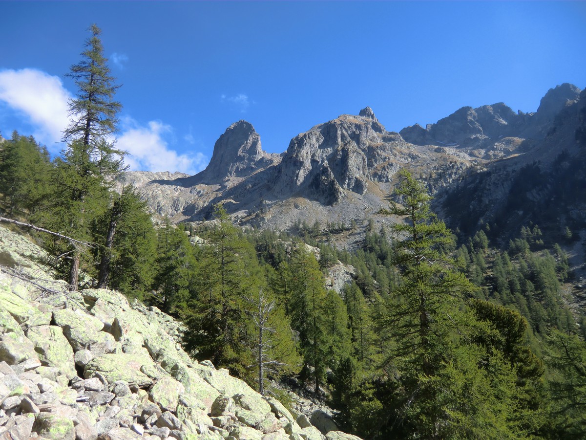
The upper region of Boréon is extremely popular during the summer season. The magnificent forest, good variable trails, and super views over the mountains…Most of the trails go inside the Mercantour National park. Here you can find everything from leisurely walks to demanding Alpine trails.
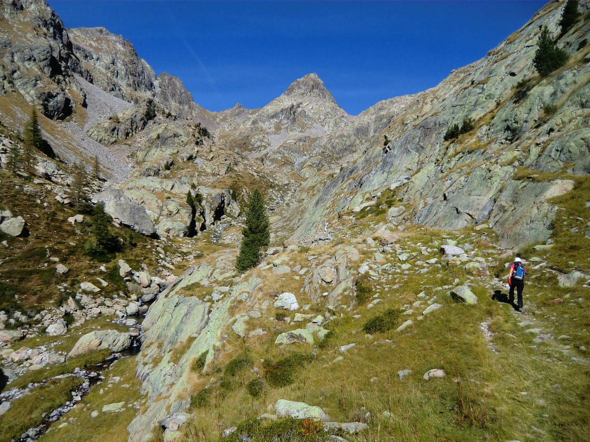
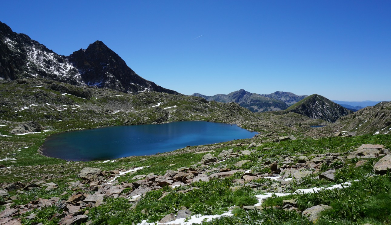
One of the classic hikes goes up to Lacs Bessons (2545 m). The twin lakes are located in their basins under Tête de la Ruine (2984 m) and several other peaks approaching 3000 m.
The main season for this hike is from July to October. The first part of the trail is the GR 52; we used the lower parking at 1600 m. The upper parking is at 1660 m altitude but mind the potholes in the last part of the road! We followed the GR 52 heading to Refuge de Cougourdeto signpost # 423 and further to signpost #424. This is the crossroads where we turned left following the narrow path in the woods. It is neither signposted nor marked with any colours, just cairns, heaps of stones. We followed closely the trail to Vallon Sangué, and came gradually above the tree line. Here the trail leveled off a bit, heading northwest. We crossed the stream that ran in the valley a few times. At the confluence of two streams the trail headed north, and started to climb steeply again. We ascended to Lacs Bessons Valley. Once again we crossed the little stream before climbing steeply northeast in a rocky mountain slope. After this ascent, we again turned north then northwest and then finally the first lake was in front of us. The landscape was truly sauvage. On the way up, we saw numerous marmots a few chamois. The solitude was remarkable. We heard the marmots’ screams but nothing else.
We climbed a little further, and could see the upper lake and the isthmus between them. We had our picnic by the lakes, and then returned along the same trail. Serious hikers might consider continuing to the nearby peaks such as Tête de la Ruine.
This itinerary is recommended only in good weather. Poor visibility and rain can make some parts of the trail dangerous.
Total ascent: 940 m (from the lower parking at Boréon)
Duration: 6 hours
The small dishes, antipasti, tapas, meze, which are served in cafés, restaurants and bars have a long tradition in the Mediterranean countries. In Italy, antipasti are served in restaurants at the table to begin a meal. Good Italian restaurants still have impressive and delicious antipasti buffets, and it is well accepted nowadays that you skip the pasta if you have enjoyed the antipasti buffet.
By chance I came across my notes of a truly magnificent antipasti buffet that we enjoyed at our hotel during a skiing trip in Madonna di Campiglio many years ago. At home, nobody would cook an antipasti buffet like that followed by pasta, main course and dessert, but I thought why not have antipasti as dinner and nothing else.
These varied small dishes enjoyed with a glass of chilled rosé, a green salad and good country bread can keep you happy on a summer evening without cooking the pasta or heating the barbecue. Many of these dishes can be cooked ahead of time. The following four dishes are just a tasty sample of the sumptuous antipasti buffet served in Madonna di Campiglio.
Dish 1.
Mix together sliced, tinned Italian artichokes, baby salad leaves, cooked prawns, minced flat-leaf parsley and freshly ground black pepper. Make a dressing of 1 part of freshly pressed lemon juice and 3 parts of fruity olive oil. Pour the dressing over the salad just before serving and toss.
Dish 2.
Toss together cooked brown beans, minced parsley and vinaigrette. Make a vinaigrette of 1 part of red wine vinegar and 3 parts of tasty olive oil. The beans are best if soaked overnight and cooked just before serving. If you use tinned beans, rinse thoroughly in cold water and dry before mixing with parsley and vinaigrette.
Dish 3.
Mix together thinly sliced courgette, and thinly sliced cold roast beef. Pour over some vinaigrette and toss.
Dish 4.
Thinly slice an aubergine and brush olive oil on the slices. Roast the slices in 200 degrees Celsius for about 20 minutes until soft. In a frying pan, fry sliced mushrooms with some garlic in rapeseed oil. Mix together the aubergine and mushroom slices. Toss in a little vinaigrette and grind over some black pepper.
The summit of Grand Glaiza (3293 m/10804 feet) in Queyras can be ascended from south by following a very long ridge called Crête aux Eaux Pendantes. The northern side of the mountain facing Italy is very steep.
Experts claim that ascending Grand Glaiza is easy. Even so, to reach this altitude means that you need to negotiate some steep parts, and the final ascent always is rocky, and often lacks a visible path. In any case, the ascent is long, and the altitude takes its toll.
We started the ascent from the refuge of Torrents les Fonds (2040 m) in the beautiful and tranquil valley of la Cerveyrette. From the village of Cervières, we drove along a good albeit narrow paved road D89T to the parking les Fonds just before the refuge.
We crossed the river after having passed the refuge, and found the signpost showing the GR58 trail towards Col du Malrif (2866 m). The trail first ascended gently in the verdant valley. In south, the summits of Pic Lombard (2975 m) and Petit Rochbrune(3078 m) and their steep northern precipices dominated the scenery. The trail followed the stream named PierreRouge for quite a while, to about 2500 m altitude. The mountain ridge was now well visible in front of us. We climbed along a steep and rocky trail as far as to Col du Petit Malrif (2830 m). From the mountain pass, we already had a great view of the biggest of the Malrif Lakes namely le Grand Laus below us. We continued heading northeast climbing to the nearby Pic du Malrif (2906 m). From here, we admired the nearby peaks, notably the majestic Mont Viso (3841 m).
From Pic du Malrif, we descended a little along the trail to Col du Malrif (2866 m). At this point, we left the GR58 trail and followed the well visible trail along the long mountain ridge. There were only cairns, no other marks. Some parts of the trail ran in gentle grass, but the higher you ascended, the rockier the trail came. Our goal, Grand Glaiza was looming in front of us. Once over 3000 m, we started to feel the altitude when struggling uphill. The last 30 vertical meters or so became a bit difficult as the trail was hard to see. The terrain was rocky with a lot of moving slate. Once at the summit, the verdant Thures Valley on the Italian side was seen over 1000 m below. In north, the partly snow-covered Vanoise summits were visible but some clouds prevented from seeing Mont-Blanc.
We returned along the same trail and had our well-deserved picnic a bit lower.
Our second day in St-Véran (2040 m) started with rain and thunder. However, after breakfast the weather improved, and we decided to start the hike along the GR58 towards Ceillac.
Our initial goal was Col des Estronques (2651 m) and the nearby Tête de Jaquette (2757 m) roughly halfway between St-Véran and Ceillac. The trail first descends about 200 m from the village centre, then ascends about 800 m to the mountain pass.
The trail was good and well-marked (GR trails usually are). We first climbed rather steeply in the beautiful woods. This trail was much less frequented than yesterday’s trails from Chapelle de Clausis. Once past the tree line, we reached a verdant alpine meadow where the ascent was less strenuous. Col des Estronques eventually came visible in front of us. Unfortunately, at the same time, the weather deteriorated rapidly. We had about 50 vertical meters left to climb when a fierce thunderstorm was right above us. The mountain pass in front of us disappeared. We had barely time to grab our raincoats when the rain started. We now saw several hikers carrying large rucksacks coming fast down from the Col des Estronques, probably doing the several day Tour of Queyras.
We descended rapidly. Luckily the weather often changes quickly in mountains. After about 30 min or so the storm had passed, there were even some sunny spells, and we could enjoy our picnic on a mountain side further down.
In spite of not reaching our goal on this hike, we actually did more climbing than on the first day. Don’t try to push on in high terrain when the weather is deteriorating. We knew that it could happen, and chose an itinerary from where it was easy to turn around if needed.
The following healthy but melt-in-mouth dessert is quick to assemble. It is essential that you use the best ingredients: tasty local strawberries and goodquality honey.
Here in Nice I use Provençal lavender honey, miel de lavande, from Manosque, they export to several European countries). I use local strawberries from Carros which are in season from April to mid- June. I use fromage blanc0% fat, French soft cheese. Elsewhere this can be substituted with Italian mascarpone.
2 servings
2 heaped tbsp. fromage blanc 0% fat or mascarpone
About 250 g local strawberries in season
1 heaped tbsp. good quality honey
1 vanilla pod
Dark chocolate shavings
Place the honey in a small saucepan. Cut the vanilla pod in half, then lengthwise. With a small sharp knife scrape the seeds into the honey, then place the vanilla pod in the saucepan. Infuse by warming very gently.
Meanwhile wash, dry and half the strawberries. Save a few small ones for decoration. Place one heaped tbsp. fromage blanc or mascarpone in the centre of the plates. Arrange the strawberries on top and around the cheese. Sprinkle with the infused honey and decorate with vanilla pods and dark chocolate shavings.
The village of St-Véran (2040m) in the Queyras Regional Park is said to be the highest village in Europe. Obviously there are higher settlements, notably ski resorts but perhaps they do not have a village status.
St-Véran is known of its high wooden houses with attic balconies as well as several sundials. In winter, it forms a ski resort together with neighbouring Molines-en-Queyras. Situated in the heart of Queyras, St-Véran is a very popular hiking centre in summer. The GR58 long-distance trail (Tour of Queyras) goes through the village.
The ascent to Pic Caramantran (3025m) is the easiest 3000+ summit that we have done so far.
From the village, we took the shuttle bus to the parking (2340m) just below the Chapelle de Clausis. The navette was mandatory (unless you prefer to walk!) in July and August as no private vehicles were allowed on this ca 5 km long dirt road. From the parking, we walked a bit towards the chapel, and located the GR58 trail. We started ascending east towards Col de Chamoussière (2884m). GR58 is well marked and signposted. Once at the col, we saw a lot of hikers climbing from the opposite direction namely from Col Agnel (2744 m) from the D205 road, hence having an especially easy ascent. Our goal, Pic Caramantran was looming above. We took the well visible trail to the summit. At the same time, the weather was deteriorating. Dense clouds rose from east preventing the views, in particular towards Mont Viso (3841m). We nevertheless reached the summit after a 35 min ascent from Col de Chamoussière. At least we could see Le Pain de Sucre (3208m) and the neighbouring Pic d’Asti (3220m) between the clouds.
From the summit, we initially decided to descend along the same trail because distant thunder was heard from the Italian side. Further down, we forked left from GR58 at about 2700m altitude and headed south towards Refuge de laBlanche (2499m). You could walk almost anywhere on a soft alpine meadow, we just had to mind the marmot potholes and some wet areas.
At the refuge, we had coffee and blueberry tart. From here, we headed back towards Chapelle de Clausis. There were many trails used by hikers, mules and donkeys. From the chapel, we descended to the parking, and took the shuttle bus back to St-Véran.
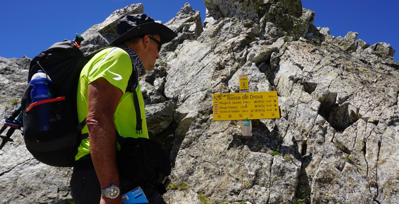
Just before mid-July, snow and hail fell over Isola2000 mountain resort. We made the hike from the village to Baisse de Druos(2628m) after two sunny days, and patches of snow were still visible in the terrain, and even on the trail in places as you climbed higher.
This is a beautiful and a very popular hike. In spite of its popularity, you have a good chance to spot chamois, especially early in the morning and late afternoon.
From Isola Village (870 m) in the Tinée Valley we followed the sinuous road up to Isola2000, and located Hotel Diva (2070 m) in the upper part of the village where the trailhead of our hike was at signpost #90.
The itinerary described in the randoxygène guide first went to signpost #90a (about 300m), then forked left to the Terre Rouge Lakes where the path climbed steeply in the woods to signpost #91 near a ski run that looked more like a wide dirt track in summer. We opted to walk a bit further passing some new chalets, then forked left and climbed next to a grassy ski run, soon reaching the same crossroads at #91. A small detour but perhaps an easier start. From this point, we followed the trail to the lakes and Baisse de Druos in most beautiful surroundings, no ski lifts were in sight anymore! We reached The Terre Rouge Lakes soon after signpost #92. These lakes seemed to be popular picnic spots. We, however, continued along a good trail to signpost #93 where we forked right and ascended towards Baisse de Druos. From the mountain pass, the trail descended to Italy and the Valscura Lakes. If you want a more demanding adventure in an alpine environment, consider conquering Mont Malivern (2938 m) north of Baisse de Druos (2 hours extra).
We returned along the same trail to Isola2000. Several chamois were spotted on the way back, and were captured in our video footage.
This easy and quick pasta dinner is super in spring and summer when fresh basil is available, the grill season starts, and you don’t want to spend hours in the kitchen. The soft and round tastes of avocado, parmesan and some crème fraîche go very well with beef.
I have chosen ready-made beef skewers from our supermarket in Nice. These have been consistently of good value and make the dinner even quicker to prepare. But if you wish to assemble you beef skewers yourself, it won’t require much time.
Good avocados are not easy to find these days. They are often either hard and tasteless or already dark and mushy inside. If you have to discard the avocado, it can be replaced by 2 tbsp. olive oil.
2 servings
1 avocado
½ clove garlic, minced
½ bunch basil leaves
2 tbsp. crème fraîche, 15% fat
About 6 tbsp. grated parmesan
2 tbsp. olive oil
Freshly ground black pepper
Whole wheat spaghetti for 2 servings
A package of 4 beef skewers
1 tbsp. butter and 1 tbsp. rapeseed oil, huile de Colza, for the grill pan.
First make the cold green spaghetti sauce. Wash and dry the basil leaves. Peel the avocado, remove the stone and cut into chunks. Grate about 6 tbsp. parmesan and crush ½ clove garlic. Place the avocado chunks, minced garlic, basil leaves crème fraîche, grated parmesan, olive oil and some black pepper in a blender and mix until smooth. Pour the mixture into a large dish.
Cook 2 servings whole wheat spaghetti and set the casserole aside.
Meanwhile place the butter and rapeseed oil in the grill pan and heat it over high heat. Quickly fry the beef skewers on all sides. Set the grill pan aside. If you want to barbecue the skewers, have the barbecue ready at the same time as the spaghetti is cooked and then quickly grill the skewers.
Mix the cooked spaghetti with the green sauce in the dish. Divide the spaghetti in bowls and place two beef skewers on top. Grind over some black pepper.
Lucéram (650 m) is only 28 km from Nice. Medieval Lucéram was a fortified town at a strategic location on one of the salt roads between the Riviera and Piemont. Along these routes, the Genoese sent oil, salt and dried and salted fish north and got flour, cheese and red wine in return.
The elderly in Lucéram still speak a local dialect which is said to be Occitan with a Piemontese twist. The main church and the chapels in the village are famous for their late medieval artworks.
We started the hike called Circuit du Grand Brausfrom signpost #170 in the village centre and walked past the tourist office to the church. The first part of the trail is GR510 with white and red signs. After the church, the trail crosses a small tributary of the Paillon River. We ascended to Col de la Plastra (977 m), and continued from there along an unpaved road about 200 m to signpost #174. Here we forked sharply left leaving the GR510 and followed the trail now marked with yellow to Caire de Braus (1273 m). The ascent from the village to this point was almost continuous.
We then followed the ridge with excellent views down to Lucéram north passing Grand Braus (1331 m), then descended a bit to Col de l’Ablé (1149 m) where we found a perfect spot for our picnic. On the day of our hike, there was a local rally passing us on the nearby RD54.
After the break, we followed an unpaved road heading west to signpost #180. At this point, we forked left following the trail that descended rapidly first in a pine woods then passing some beautiful meadows and lime trees(tilleul) to signposts #183 and #184 before reaching Lucéram.
Total ascent: 740 m
Duration: 4 h
Map: IGN IGN 3741 ET “Vallées de la Bévéra et des Paillons”