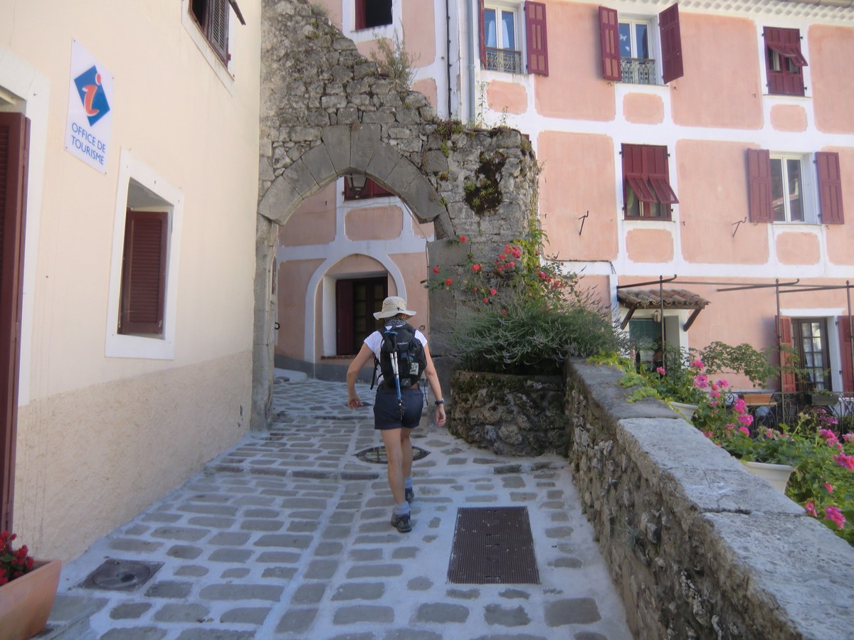
The village of St-Véran (2040m) in the Queyras Regional Park is said to be the highest village in Europe. Obviously there are higher settlements, notably ski resorts but perhaps they do not have a village status.
St-Véran is known of its high wooden houses with attic balconies as well as several sundials. In winter, it forms a ski resort together with neighbouring Molines-en-Queyras. Situated in the heart of Queyras, St-Véran is a very popular hiking centre in summer. The GR58 long-distance trail (Tour of Queyras) goes through the village.
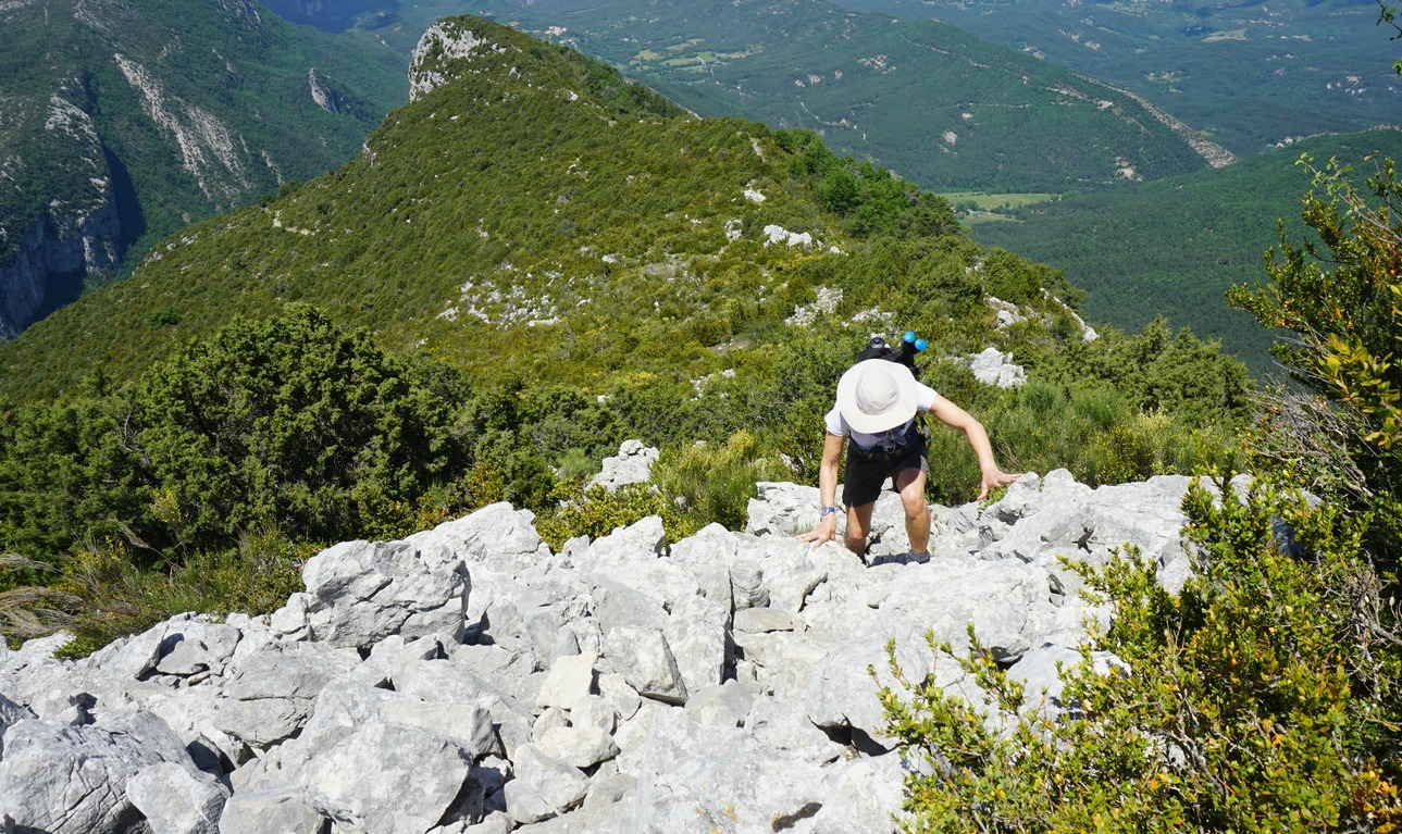
The ascent to Pic Caramantran (3025m) is the easiest 3000+ summit that we have done so far.
From the village, we took the shuttle bus to the parking (2340m) just below the Chapelle de Clausis. The navette was mandatory (unless you prefer to walk!) in July and August as no private vehicles were allowed on this ca 5 km long dirt road. From the parking, we walked a bit towards the chapel, and located the GR58 trail. We started ascending east towards Col de Chamoussière (2884m). GR58 is well marked and signposted. Once at the col, we saw a lot of hikers climbing from the opposite direction namely from Col Agnel (2744 m) from the D205 road, hence having an especially easy ascent. Our goal, Pic Caramantran was looming above. We took the well visible trail to the summit. At the same time, the weather was deteriorating. Dense clouds rose from east preventing the views, in particular towards Mont Viso (3841m). We nevertheless reached the summit after a 35 min ascent from Col de Chamoussière. At least we could see Le Pain de Sucre (3208m) and the neighbouring Pic d’Asti (3220m) between the clouds.
From the summit, we initially decided to descend along the same trail because distant thunder was heard from the Italian side. Further down, we forked left from GR58 at about 2700m altitude and headed south towards Refuge de laBlanche (2499m). You could walk almost anywhere on a soft alpine meadow, we just had to mind the marmot potholes and some wet areas.
At the refuge, we had coffee and blueberry tart. From here, we headed back towards Chapelle de Clausis. There were many trails used by hikers, mules and donkeys. From the chapel, we descended to the parking, and took the shuttle bus back to St-Véran.
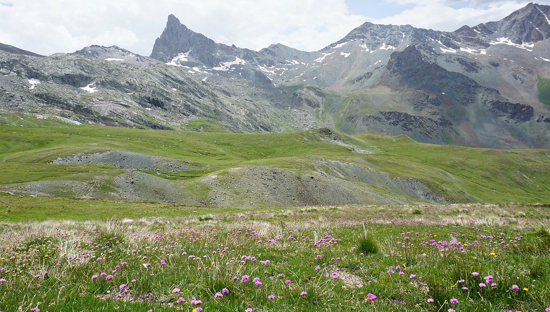
Just before mid-July, snow and hail fell over Isola2000 mountain resort. We made the hike from the village to Baisse de Druos(2628m) after two sunny days, and patches of snow were still visible in the terrain, and even on the trail in places as you climbed higher.
This is a beautiful and a very popular hike. In spite of its popularity, you have a good chance to spot chamois, especially early in the morning and late afternoon.
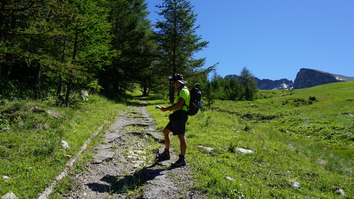
From Isola Village (870 m) in the Tinée Valley we followed the sinuous road up to Isola2000, and located Hotel Diva (2070 m) in the upper part of the village where the trailhead of our hike was at signpost #90.
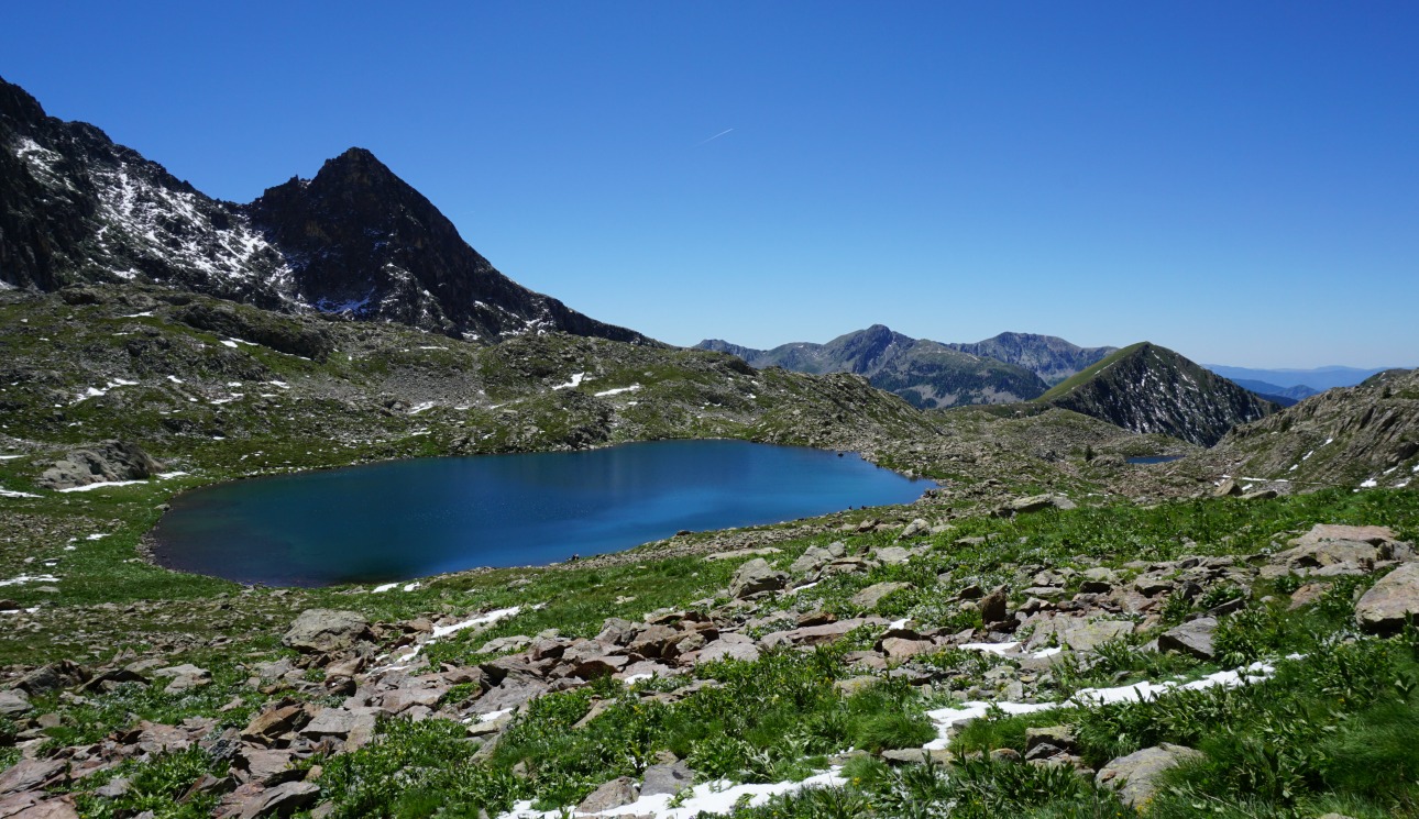
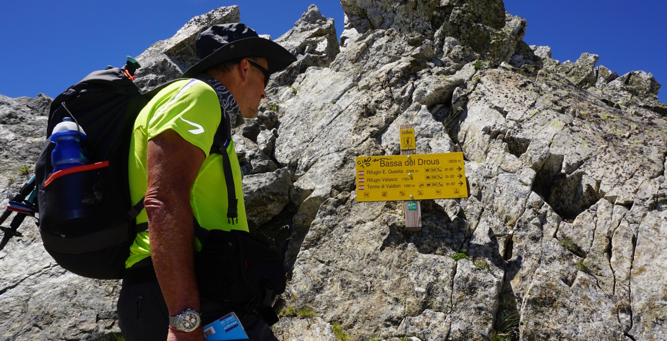
The itinerary described in the randoxygène guide first went to signpost #90a (about 300m), then forked left to the Terre Rouge Lakes where the path climbed steeply in the woods to signpost #91 near a ski run that looked more like a wide dirt track in summer. We opted to walk a bit further passing some new chalets, then forked left and climbed next to a grassy ski run, soon reaching the same crossroads at #91. A small detour but perhaps an easier start. From this point, we followed the trail to the lakes and Baisse de Druos in most beautiful surroundings, no ski lifts were in sight anymore! We reached The Terre Rouge Lakes soon after signpost #92. These lakes seemed to be popular picnic spots. We, however, continued along a good trail to signpost #93 where we forked right and ascended towards Baisse de Druos. From the mountain pass, the trail descended to Italy and the Valscura Lakes. If you want a more demanding adventure in an alpine environment, consider conquering Mont Malivern (2938 m) north of Baisse de Druos (2 hours extra).
We returned along the same trail to Isola2000. Several chamois were spotted on the way back, and were captured in our video footage.
This easy and quick pasta dinner is super in spring and summer when fresh basil is available, the grill season starts, and you don’t want to spend hours in the kitchen. The soft and round tastes of avocado, parmesan and some crème fraîche go very well with beef.
I have chosen ready-made beef skewers from our supermarket in Nice. These have been consistently of good value and make the dinner even quicker to prepare. But if you wish to assemble you beef skewers yourself, it won’t require much time.
Good avocados are not easy to find these days. They are often either hard and tasteless or already dark and mushy inside. If you have to discard the avocado, it can be replaced by 2 tbsp. olive oil.
2 servings
1 avocado
½ clove garlic, minced
½ bunch basil leaves
2 tbsp. crème fraîche, 15% fat
About 6 tbsp. grated parmesan
2 tbsp. olive oil
Freshly ground black pepper
Whole wheat spaghetti for 2 servings
A package of 4 beef skewers
1 tbsp. butter and 1 tbsp. rapeseed oil, huile de Colza, for the grill pan.
First make the cold green spaghetti sauce. Wash and dry the basil leaves. Peel the avocado, remove the stone and cut into chunks. Grate about 6 tbsp. parmesan and crush ½ clove garlic. Place the avocado chunks, minced garlic, basil leaves crème fraîche, grated parmesan, olive oil and some black pepper in a blender and mix until smooth. Pour the mixture into a large dish.
Cook 2 servings whole wheat spaghetti and set the casserole aside.
Meanwhile place the butter and rapeseed oil in the grill pan and heat it over high heat. Quickly fry the beef skewers on all sides. Set the grill pan aside. If you want to barbecue the skewers, have the barbecue ready at the same time as the spaghetti is cooked and then quickly grill the skewers.
Mix the cooked spaghetti with the green sauce in the dish. Divide the spaghetti in bowls and place two beef skewers on top. Grind over some black pepper.
Lucéram (650 m) is only 28 km from Nice. Medieval Lucéram was a fortified town at a strategic location on one of the salt roads between the Riviera and Piemont. Along these routes, the Genoese sent oil, salt and dried and salted fish north and got flour, cheese and red wine in return.
The elderly in Lucéram still speak a local dialect which is said to be Occitan with a Piemontese twist. The main church and the chapels in the village are famous for their late medieval artworks.
We started the hike called Circuit du Grand Brausfrom signpost #170 in the village centre and walked past the tourist office to the church. The first part of the trail is GR510 with white and red signs. After the church, the trail crosses a small tributary of the Paillon River. We ascended to Col de la Plastra (977 m), and continued from there along an unpaved road about 200 m to signpost #174. Here we forked sharply left leaving the GR510 and followed the trail now marked with yellow to Caire de Braus (1273 m). The ascent from the village to this point was almost continuous.
We then followed the ridge with excellent views down to Lucéram north passing Grand Braus (1331 m), then descended a bit to Col de l’Ablé (1149 m) where we found a perfect spot for our picnic. On the day of our hike, there was a local rally passing us on the nearby RD54.
After the break, we followed an unpaved road heading west to signpost #180. At this point, we forked left following the trail that descended rapidly first in a pine woods then passing some beautiful meadows and lime trees(tilleul) to signposts #183 and #184 before reaching Lucéram.
Total ascent: 740 m
Duration: 4 h
Map: IGN IGN 3741 ET “Vallées de la Bévéra et des Paillons”
The following easy and tasty recipe is great to make in summer or spring. Although fresh red mullet, rouget, fillets now seem to be available year round in our supermarket in Nice, one has to wait until spring to find small thin babycourgettes and fresh basil in shops. This carefree recipe is modified from a French recipe in a booklet from our supermarket.
2 servings
About 300 g red mullet fillets
3 tbsp. olive oil
About 10 cherry tomatoes
2 baby courgettes, cut into chunks
About 3 tbsp. grated Parmesan
1 egg white
Fresh basil to decorate
Optional: black pepper and a pinch of salt
Lemon wedges and steamed new potatoes to serve
NB! Fresh lemon squeezed on the fish effectively reduces the need for salt! There is already salt from the Parmesan.
Preheat the oven to 210 degrees Celsius, roast.
Wash the cherry tomatoes, baby courgettes and potatoes. Cut the courgettes into chunks. Make four vegetable skewers by alternating the cherry tomatoes and courgette chunks.
Line a large oven tray with baking paper and brush it with 1 tbsp. olive oil. Place the vegetable skewers in the tray.
Grate about 3 tbsp. Parmesan. In a small bowl whip the egg white into a foam. Place the red mullet fillets in the oven tray skin side up. Brush the fillets with egg white and sprinkle with Parmesan. Place the tray in the oven and roast for 8 minutes.
Meanwhile microwave the new potatoes.
Divide the red mullet fillets, skewers and potatoes on the plates. Sprinkle the potatoes with olive oil and decorate with basil leaves. Serve with lemon wedges.
The village of Moulinet (800 m) is situated between Col de Turini and Sospel by the Bévéra River.
In the 1880s, the affluent new Côte d’Azur residents didn’t tolerate well the hot summers and searched for cooler places not far from the coast. After the road between Sospel and Moulinet was built in 1883, Moulinet became a fashionable summer resort. It was even compared to Switzerland, and its popularity blossomed after the road to Col de Turini was completed in 1928.
Today’s Moulinet is very tranquil but charming. It makes a nice stop for a coffee or sandwich sitting beneath the plane trees outside the café in the centre of the village.
We got the inspiration for this hike from the loop trail called Baisse de Peïra Cava described in the randoxygène guide.
However, it felt natural to us to make the loop clockwise, and to include the ascent (only about 70 m extra climbing) to Cime de Peïra Cava (1581m) in our itinerary. We were awarded with a super panorama!
We started ascending from signpost #1 from the village square along a shaded narrow street marked by red and white GR signs. We followed the GR signs only about 100 m passing Epicerie du Mercantour, then ascended to Place St-Roch. NB! Don’t turn left along the GR52A descending towards Sospel but continue straight taking stairs to the Place St-Roch with the communal washing place.
At the other end of the square we found signpost #10 to Baisse de Peïra Cava. The signpost was not easy to spot, we had to ask for directions. From here, we walked in the valley of Peïra Cava passing signposts # 9,8 and 7. At signpost #7, we continued straight (forking left would have taken us to Baisse de Beccas) for about 20 minutes. The main trail then turned left towards Peïra Cava (an unofficial signpost!) and we started to ascend steeply in a pine and beech woods. What a magic path this was!
We reached Beccas (1340 m) by a wide forest road after about 30 min. We continued ascending gently along this road further enjoying the magnificent forest. This was Forest Therapy at its best! After a while we reached Baisse de Peïra Cava (1508 m, signpost #179). From here, we took a trail straight south and ascended to Cime de Peïra Cava. The panoramic views to south and the coast as well as west were exceptional. The tree line reached the northern flank of the little summit, preventing the views to north and east.
After a break and picnic at Cime de Peïra Cava we returned to Baisse de Peïra Cava, and from signpost #179 we continued north towards Col de Turini to signpost 180. From there we continued northeast in a super fir forest still towards Col de Turini and Baisse de Pourcel as far as signpost #34. At signpost #34 (1600m) we reached the GR52A trail, and started the long descent along it back to Moulinet. Most of the trail was really pleasant and wide. The markings were better than 5 years ago when we had descended along it from Col de Turini to Sospel, thanks partly to the mountain bikers!
Total climb: 870 m
Duration: 5h 15- 5h 30
Map: IGN 3741 ET Vallées de la Bévéra et des Paillons
The tiny village of Sigale (630 m) is situated in the heart of the Estéron Valley about 1h 15 min drive from Nice. Sigale has its special charms, notably the clocktower which proudly dominates the valley. From the clock tower you have a nice view towards Cime de la Cacia (1105 m), and the Rivers Estéron and Riolan. But it is the summit of Cime de la Cacia and its super 360° panorama which today is our goal. It is the highest point of the loop called Circuit de la Cacia in the randoxygène guide.
From the parking at the entrance of the village we started ascending from signpost #121. The wide trail that is also GR510 in the beginning goes to signpost #122. Here, our trail forked right (now yellow marks), leaving the GR510, and we ascended rather steeply to collet de la Cacia and signpost #136. From this point, we made a detour climbing straight east along the ridge to the summit of Cime de la Cacia, and reached the mountaintop after about 15 min.
We descended back to signpost #136 and continued the hike by descending to signpost #135 on the northern side of the mountain. We soon dove into a beautiful forest (Bois de la Cacia). Once again, we could see the change in the landscape when coming to the northern side of the mountain ridge in the Estéron Valley.
After a break at signpost 135 we continued straight west. Our trail first ran almost horizontally in the woods. Another trail descended to the north down to the Valley of Pali. This was not our itinerary, be aware! Eventually, we came to signpost #140 by the RD17 road above the gorge of the Riolan River(a tributary of the Estéron River). We walked along the road about one km admiring the spectacular views, and minding the traffic which was light. From the RD17 road, we forked right at signpost 139 and descended to the GR510 trail and walked along it back to the village.
Duration: 4h30
Vertical climb: 650 m
Map: IGN 3642 ET Vallée de l’Estéron Vallée du Loup
Near the end of April, cherry trees in Provence explode with white blossoms. In May and June dark cherries, cerises noires, are in season. A single cherry tree may produce about 50 kg fruit. Maybe this is the reason why cake recipes in the South of France contain much more fruit and much less flour than Northern European cake recipes.
The following easy recipe is a bake, clafoutis, and not a serious cake recipe. The clafoutis comes from the Limousin region and was traditionally made with dark cherries. The clafoutis can also be made with other seasonal fruit.
I have somewhat modified the original recipe from an old Provencal cookbook by baking it in small individual ramekins and by replacing Beaumes-de-Venise sweet fortified wine by orange juice. I have also replaced the traditional sugar decoration with a few fresh cherries.
For four ramekins
About 400 g dark cherries
2 eggs
4,5 tbsp. brown sugar, cassonade
2,5 tbsp. flour
A pinch of grated nutmeg, muscade
125 ml milk
4 tbsp. orange juice
Butter
Preheat the oven to 200 degrees Celsius.
Butter four ramekins.
Wash and dry the cherries. Save 16 cherries for decoration and remove the stones and stalks from the rest. Divide the pitted cherries in the ramekins.
In a bowl whisk the eggs, sugar and nutmeg. Then add the flour in small amounts and mix well. Add the milk and orange juice and mix again. Divide the batter in the ramekins.
Bake in the oven for 20- 25 minutes until the surface is nicely coloured, and a wooden pick inserted comes out dry.
Serve the ramekins at room temperature or cold. Just before serving decorate each ramekin with four fresh cherries.
In Colman Andrews’ book Flavours of the Riviera, the author describes a casual after-dinner conversation with the owner of Da Puny Restaurant in Portofino. The restaurant was, and still is, catering for well-to-do international guests to Portofino. The author got the busy restaurant owner talking about the realLiguriancuisine.
During the conversation the restaurant owner revealed his opinion of the most perfect pasta sauce in the world. “You have to cook it on a boat. You catch some sardines, then you grill them right on deck. Then you put olive oil, capers and garlic in a pan-that’s all-and throw in the sardines. Put that on some pasta and you simply don’t need anything else. It’s the best.”
Well, here in Nice we don’t own a boat to catch some sardines, but we do often have very fresh sardine fillets in our local supermarket. So I decided to give this simple recipe a try.
Here is my recipe based on the description of the dish. Is it “the best in the world”? That is for everyone to decide, if you have access to really fresh sardines.
2 servings
About 250- 300 g very fresh sardine fillets
3 tbsp. olive oil
1 clove garlic, minced
4 tsp. tasty Italian capers
Whole wheat spaghetti for 2 servings
Fresh chives to decorate
Preheat the oven to 200 degrees Celsius.
Clean the sardine fillets with kitchen paper and lightly brush with olive oil. Grill them in the oven for 10 minutes.
Meanwhile cook the spaghetti until al dente. Heat the olive oil in a frying pan over medium heat and saute the minced garlic. Add the capers and the grilled sardines.
Drain the pasta and divide in two bowls. Divide the pasta sauce over the spaghetti and decorate with chives.
The 6085 road north from Grasse is called the Route Napoléon. It was built in the 1930s to commemorate the Emperor’s journey in March 1815 after his escape from Elba. St-Vallier-de-Thiey (720 m) is the first small town after Grasse. It makes a nice stop before driving further. The RD 6085 road continues to the rather touristic Castellane and beyond, but we left it after about 30 km and turned right to the Provençal village of Séranon (1100 m).
Séranon is one of the villages in Moyen Pays where you can start your hike at over 1000 m altitude. We found a big parking at the village entrance, just after the roundabout. We then walked about 300 m to the village centre.
Today’s hike is called Crête du Bauroux in the Randoxygene booklet. The highest point (1644 m) on this trail is the summit of Bauroux in the easternmost part of the over 3 km long ridge overlooking Séranon.
We found the signpost #192 next to the mairie. The first part of the trail was also GR510 heading west and climbing gently. At signpost #214 we forked right. The trail ascended more steeply directly to signpost #194 and the ruins of the Vieux Séranon (1320 m). After descending about 30 meters at the crossroads of several trails, we took the one heading east in the forest. We walked on the northern side of the ridge on a good path, and had views only to the north. The trail made several short ascents and descents. Only when we approached the summit, we left the forest below us and could enjoy the panorama.
From the summit, we descended steeply in a north-easterly direction. The trail was good all the way but at this stage it was good to have the poles. We came to Col Bas and signpost #182, then #181. We crossed the D80 and 79 roads and followed the trail that ran beside a field to the village of Caille (signpost #180). From the village, we walked along the D79 road about 400 m, then turned right at signpost #197, and followed a wide trail that led back to Séranon.