Cime du Pisset above Boréon

Goats on the trail to Cime du Pisset


Ascending from the upper parking of Boréon


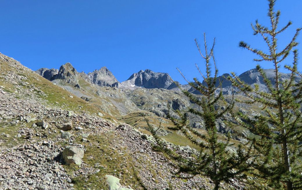
Cime du Pisset (2233 m) is one of the lesser known summits in Mercantour National Park. It offers nevertheless a magnificent view over the higher summits nearby such as Gélas, Malédie, Caïres de Cougourde etc. In winter, the trail to the summit is one of the snowshoeing itineraries.
Caïre de Cougourde seen from the trail


It takes about 1h 20 (70 km) to drive to Boréon from Nice. Drive past the reception building, turn right and continue 1,6 km to the lower parking (1610 m elev.). The upper parking is at 1660 m, but the last part of the road is unpaved with a lot of deep potholes.
Midway to Pas de la Maïris from Boréon

Sheep flock on the way to Cime du Pisset


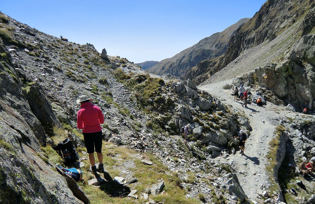
Walk past the cowsheds to the upper parking, where you enter the Mercantour National Park and see signposts showing several itineraries. Follow the main cobbled path a few hundred meters. Here, the trail to Cime du Pisset forks right at signpost # 421. The trail marked with yellow ascends steeply in the woods to signpost # 432 and further to Pas de la Maïris above the tree line (1h 20, 2106 m elev.). The undulating mountaintops on the ridge comprise mainly alpine meadows. The signpost # 431 is the crossroads either to our goal today, down to the next valley (Madone de Fenestre), or west to Cime de Piagu and further. For Cime du Pisset, turn left (east) and follow the well visible path that soon starts ascending. Most of the climbing is already done; the last part ascends only about 130 m or so to the grassy summit.
The gentle trail ascending to Cime du Pisset Gélas in background

Back to Boréon from Pas de la Maïris


If you meet a sheep flock on the trail, step aside and wait for it to pass. The shepherds have full control over the sheep dogs and will tell you when you can continue.

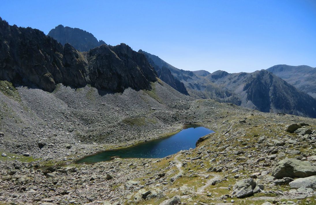
Even on a partly cloudy day, and in spite of the “modest” altitude, the scenery is fantastic. It is a perfect spot for a break & picnic, too. Return along the same trail.

Cime du Pisset trail image
Climb:  630 m

Duration:          3h 15


Map:                IGN 3741 OT Vallée de la Vésubie


Image of trail courtesy of Google Maps

Rabbit with carrots

Rabbit with carrots


Rabbit has traditionally been as familiar on the table as chicken or duck in the Mediterranean countries. Lapin à la moutarde, rabbit with savory mustard sauce, is a very typical French recipe.

The following simple recipe is a twist of this French classic. Somehow the carrots, fresh thyme, rabbit and grainy mustard, moutarde à l’ancienne, wonderfully complement each other in this recipe.

Rabbit is very low in fat. For convenience I have used rabbit fillets which are easy to cut into smaller chunks. The recipe can also be made of skinless chicken breast cut into smaller chunks.

2 servings

About 300 g rabbit fillets, cut into about 2,5  x 2,5 cm chunks
3 carrots, sliced
1 medium onion, chopped
1 clove garlic, minced
2 tbsp rapeseed oil
1 ½ tbsp grainy mustard, moutarde à l’ancienne
200 ml chicken stock
50 ml white wine
A small bouquet of fresh thyme
2 bay leaves
Freshly ground black pepper

Slice the carrots and microwave until almost soft.

Wash and dry the thyme and remove the leaves from the sprigs.

Preheat the oven to 180⁰ C.

In a heavy casserole warm the rapeseed oil over medium heat. Cut the rabbit fillets into smaller chunks. Peel and chop the onion, peel and mince the garlic. Add the rabbit, onion and garlic in the casserole and fry for about 10 minutes stirring frequently until the rabbit chunks are golden brown on all sides. Add the white wine, carrots, mustard, black pepper and chicken stock. Add half of the thyme leaves, save the rest for the decoration. Stir and transfer the casserole to oven for 40 minutes.

Serve with new potatoes and Brussels sprouts or green beans. Decorate with fresh thyme leaves.

Col de Fenestre

Ibex (bouquetin) near Col de Fenestre

Col de Fenestre (2474 m), the mountain pass at the Italian border above Madone de Fenestre is ideal for spotting ibex(Bouquetin). These nearly became extinct and were reintroduced to Mercantour from Grand Paradiso on the Italian side. Every time we have visited Col de Fenestre we have seen ibexes that were half-tame and very easy to photograph.

Trails ascending from Madone de Fenestre (1903 m) are very popular. You are surrounded by the highest peaks in the region, including Cime du Gélas (3143 m). Driving time from Nice is about 1h 20/ 71 km, first to St-Martin-Vésubie from where the narrow paved road climbs to Madone de Fenestre.


Image of trail from Madone de Fenestre to Col de Fenestre

Col de Fenestre was already known by the Romans, and later became an important route between Savoy and Piemonte. Remains of military bunkers (all built by the Italians) from the early 20th century can be seen on both sides of the mountain pass. It is now at the border of the two countries. Before 1947, it belonged to Italy. It was one of the escape routes used by Jews escaping the Nazis from Nice in September 1943.

The trail from Madone de Fenestre ascends along the GR52 trail to signpost #368, then forks right and continues to Lac de Fenestre (2266 m) and further to signpost #369 just below the mountain pass. It is an easy ascent all the way. One can return along the same trail or take the trail from signpost #369 to Pas des Ladres (2448 m) to signpost # 428 then return along the GR52 trail back to the starting point.

Duration: 3 h (4 h via Pas des Ladres)
Vertical climb :    570 m (660 m via Pas des Ladres)
Map : IGN 3741 OT Vallée de la Vésubie
Info in French, via Pas des Ladres (Guide Randoxygéne)
Image of trail courtesy of Google Maps

Apple rose dessert

Apple rose dessert


When we recently visited Miami, our daughter-in-law served us this impressive apple dessert. She had got  the recipe from a friend, who had got it from somebody’s blog…Later I saw in a French magazine a similar recipe, Roses de pommes en tartelette, in which the pastry sheet was made from scratch. It just proved that French girls are formidable pastry chefs.
Ingredients for four serving of apple rose dessert


The following recipe is my twist of the two original recipes and made from ingredients bought in our  local supermarket in Nice. This elegant apple dessert will impress your guests, whether you choose to serve it with vanilla ice cream the American way, or just the tartelette the French way.
Slicing the apples for apple rose dessert


4 servings:

2 Pink Lady apples or other red apples (you don’t need to use them all)
A sheet of thin and rectangular puff pastry, pâte feuilletée
2 tbsp apricot jam plus a little water (you don’t need to use this all)
Cup cake tray
A little butter for the cup cake tray
Powdered sugar, sucre glace

Arranging apple slices on pastry strips


Wash the apples and halve them. Remove the cores and cut the apples into thin slices. I first found this the hardest part of the recipe, but the “roses” are more decorative if the slices are really thin. Microwave the slices until they are soft but not mushy.
Turning over the other long side


Preheat the oven to 180⁰ C. Butter the cup cake tray.
Rolling the strips into roses
Roll out the puff pastry from its package. Cut out 4 strips, about 5 cm wide and 25- 34 cm long.


Warm the apricot jam with a little water in microwave and mix until smooth. Brush this mixture on the pastry strips.
Apple roses ready to oven


Arrange apple slices on one long side of the pastry strip like a lace border placing the rounded skin side to the outside. The apple slices will overlap each other and cover about half of the long side of the pastry strip.

Turn over the other long side and roll the strips into “roses”. They look best if you can roll the “roses” so that the center will be slightly higher like in a real rose. I was not concentrating on this enough when rolling.

Place the “roses” in the cup cake tray and bake in 180⁰ C for about 30 minutes until nicely coloured. Sprinkle with powdered sugar before serving.


Hiking near Col de la Bonette: Cime de Pelousette 2757 m


Start of the trail to Cime de Pelousette just above Camp des Fourches

We have previously reported a moderate 4 hour day hike to Col de la Cavale from Camp des Fourches (2240 m) just before Col de la Bonette (2715 m) mountain pass.
Camp des Fourches and Tête de Vinaigre in distance seen from the trail


Magnificent mountaintops north of Camp des Fourches

Today’s hike to Cime de Pelousette (2757 m) and back takes about 3 h. The trail first ascends in alpine meadows followed by some rocky parts. Because of the altitude, the whole route is above the tree line. On a clear day like ours, navigation is easy. Even so, there are many man and animal made trails crisscrossing the terrain, hence follow the trail marked with yellow and cairns! Views are stunning all the way.

View east from Cime de Pelousette

The barracks at Camp des Fourches were occupied all year round until the end of WWII. It is difficult to imagine the life of mountain infantrymen, chasseurs alpins, as the area is covered by snow 2/3 of the year. The road is open only during the summer months.

From signpost 41, the trail forks left (north). It is not necessary to walk as far as to Col des Fourches nearby. A grassy small mountaintop called Ventabren is passed, leaving it on the right hand side of the trail. After this, the path turns to northwest climbing more steeply in rocky terrain before it levels off slightly and turns south west for about 400 m. Another steeper climb follows, and just under the summit the trail climbs straight north again before reaching the mountain crest called Crête de la Tour. From the crest, our summit is reached in just a few minutes. During the ascent, the summit of Cime de Pelousette is not actually visible as the southern flank is round, comprising alpine meadows. The northern and western flanks are, on the other hand, very steep and rocky. Don’t go inside the fortress ruins, the structures are fragile. From the summit, you can see the RM 64 road climbing up to Col de la Bonette. Cime de la Bonette (2860 m) is clearly visible in distance, also the loop road (2802 m) circling the mountain. It is said to be the highest paved road in the Alps connecting two regions.
Road to col de la Bonette seen from the summit of Cime de Pelousette


We returned to our starting point along the same trail.  

A rewarding high-altitude hike that requires little effort!

Vertical climb:            520 m

Duration:                    3 h

Image of trail to Cime de Pelousette


Map: IGN 3639 OT Haute Tinée 1

Distance from Nice 102 km


Image of trail courtesy of Google Maps

Easy seafood paella


Seafood paella is nowadays quite popular in the South of France. There are many adaptations of this most famous Spanish dish, and all sorts of dishes can be called paella.

Nancy Harmon Jenkins writes beautifully in her Mediterranean Diet Cookbook about the true paella: it can be made only with the round short grain bomba rice, it includes only chicken, rabbit and snails, it is seasoned only with saffron and paprika, it should be made only in a paella pan over an open fire and it should be cooked only by men for the midday meal. So my easy seafood paella recipe does not even pretend to be authentic, but I guarantee that it is healthy, tasty and easy to cook.

2 servings:

2 tbsp olive oil
½ large onion, finely chopped
1 clove garlic, minced
3 ripe tomatoes, chopped
1 tsp sweet paprika, paprika doux
A large pinch of saffron
120 ml instant brown rice
250 ml chicken stock
About 10- 16 shrimp, shelled
About 10- 16 mussels

Shell the shrimps leaving tails attached and place them in the fridge. In the South of France, the shrimps are usually cooked whole in paella, but this makes a “messier” eating than most people wish. I like to keep tails intact because they are so decorative and easy to remove on the plate. If you use frozen raw shelled shrimps, defrost them in the fridge for about 8 hours and keep them in the fridge until needed.

Wash the mussels and check that they are closed. If they are slightly open just knock them so that they close. Discard those that do not close. Keep them in the fridge until needed.

Make 250 ml chicken stock from a good cube.

In a large frying pan warm 2 tbsp olive oil over medium heat. Start making Spanish tomato sofrito which is a basic tomato sauce cooked from olive oil, onion, garlic and tomatoes. Add the sweet paprika and saffron in the pan and cook for about 10 minutes, stirring occasionally until the tomatoes have collapsed.

Add the rice to the pan and stir well so that the rice is well coated. Add 250 ml chicken stock and bring to the boil. Then reduce the heat to medium and cook for about 10- 12 minutes until the rice is tender. There should be a little liquid in the pan, but not too much. If the rice gets too dry, add a little water.

Add the reserved shrimps and mussels so that they are nicely nestled among the rice. Cover and cook for 4- 5 minutes until the shrimps are pink and opaque and the mussels have opened.

Serve with a green side salad.

Mercantour: The trail over Pas de l'Arpette


This alpine hike from the Gordolasque Valley over Pas de l’Arpette (2511 m) inside Mercantour National Park also offers a direct access to the mythic Merveilles Valley. The Merveilles Valley is famous for its prehistoric engravings. These are now protected, and you have to stay strictly on the path when visiting this valley.
Early morning at Pont du Countet

Start of the ascent from the Gordolasque valley


Mont Bego (2872 m) situated east of the Merveilles Valley is known to attract thunderstorms. The prehistoric inhabitants considered this mountain sacred, and the rock engravings testify of its importance.
The trail midway between Pont du Countet and Pas de l'Arpette


The hike starts from the Pont du Countet (1690 m) where the narrow paved road ascending in the Gordolasque Valley ends. The distance from Nice is 66 km by road, and the Mediterranean coast is just 32 km away as the crow flies. Pont du Countet is also an important starting point for other hikes in high terrain, such as the one going to Refuge de Nice.
Pas de l'Arpette in sight


From the parking, walk over the bridge where you find signpost # 412: Pas de l’Arpette 3 h and Merveilles 4 h. The trail (marked with yellow signs) starts to ascend steeply in the woods comprising mainly larches and Cembra (or Swiss) pines. Once over 2000 m, the trees disappear, and the scenery becomes more and more alpine. The trail levels off –but only temporarily. You have a good chance of spotting chamois, perhaps because this trail is less visited.
At Pas de l'Arpette with Mont Bego in background


The last push to Col de l’Arpette is again steeper but the trail is good. We reached the mountain pass in 2h 15 keeping just a moderate pace. On the day of our hike, the weather was perfect and the views were stunning. From the mountain pass, the Lac Long further down can be seen, as well as Refuge des Merveilles on its shore. For an overnight stay, the refuge offers simple accommodation and meals.
Lac Long and Refuge des Merveilles

The trail winds down towards the lake. The upper part of the slope comprises alpine meadows, whereas further down the terrain becomes rockier again. The vertical descent to the lake is about 400 m. A little before the lake, there’s the main crossroads where the GR52 trail forks left (north) and enters the Valley of Merveilles proper. For most of us, exploring this trail would require another day.
Chamois crossing the trail between Gordolasque Valley and Pas de l'Arpette


We returned along the same trail to Pont du Countet.


Total hiking time: 6h 30

Vertical climb:       about 1200 m
Image of trail over Pas de l'Arpette

Description in French: (the Randoxygène guide)

Map: IGN Vallée de la Vésubie 3741 OT


Image of itinerary courtesy of Google Maps

Quinoa tabbouleh with apricots and chicken skewers

Quinoa tabbouleh with apricots and chicken skewers


If you have dined at a Lebanese restaurant you will instantly recognise the Eastern Mediterranean flavours in the following recipe: olive oil, lemon juice, parsley, mint and black pepper.

Traditionally tabbouleh is made from bulgur, which is cracked wheat. This version is made from quinoa, a gluten free grain. This tabbouleh is very green - the way it is made in Lebanese restaurants.

The mild flavour of chicken goes well with the sweetness of fresh apricots. Instead of apricots you could use fresh figs when they are in season.

2 servings

120 ml quinoa
500 ml vegetable stock
2 skinless chicken breasts from free-range chicken, poulet fermier
4 fresh apricots or figs
1 lemon
5 tbsp olive oil
Freshly ground black pepper
A small bunch of fresh mint
A small bunch of fresh parsley
1 tsp ground coriander

Cut the chicken breasts into fairly large cubes and place them in a deep plate. Press half of the lemon over the chicken. Sprinkle over 2 tbsp olive oil and 1 tsp ground coriander. Grind over some black pepper. Turn the chicken cubes until well coated with the marinade, cover with foil and place in the fridge for about 30 minutes.

Meanwhile cook the quinoa in vegetable stock for 20 minutes. Cover for a few minutes and let stand until all the liquid has evaporated. Transfer the quinoa into a large salad bowl.

Wash and dry the parsley and mint. Cut the herb leaves finely, transfer to the salad bowl and mix well with the quinoa. Press the remaining half of the lemon over the herbs and quinoa and add 3 tbsp olive oil into the bowl. Mix well and keep in the fridge until ready to serve.

Wash and dry the apricots. Cut them into halves and remove the stones. Take the chicken cubes from the fridge and dry with kitchen paper.

Warm a grill pan over medium-high heat and thread the chicken cubes and apricot halves on skewers. Grill the skewers on all sides turning regularly until the chicken is done. This will take about 20 minutes.

Divide the tabbouleh and skewers on the plates and serve.


Mont Chaberton (3131 m) above Montgenèvre


Mont Chaberton seen from our hotel room


The Roman road over Col Montgenèvre was an important route connecting Turin with Spain. In 1802, a proper road was opened facilitating rapid connection Between Briancon and Turin. In 1936, the Montgenèvre ski resort was opened.


Our skiing friends have really liked Montgenèvre which in summer offers great hikes. It was again Bernard Ranc’s wonderful hiking book, Les plus belles randonnées des Alpes du Sud, which finally gave inspiration to this hike.
Easy start along GR5 from Mongenèvre to Mont Chaberton


Mont Chaberton (3131m) is one of the alpine mountains over those mythic 3000m that can be reached relatively easily. The mountain used to be Italian territory, and Fort Chaberton was constructed on the summit in 1898-1910. The summit comprises a surprisingly large man-made plateau offering a super panorama: Mont Blanc, Les Ecrins… The fortress is now completely ruined after heavy fighting during WW II.
Steep trail to Col du Chaberton


The hike starts from the centre of Montgenèvre along the GR 5 trail (red and white signs) passing the tourist office and the obelisk towards Italy. After 1.5 km the GR 5 forks left in a forest following a wide dirt road. The trail climbs gently about 2 km with a dry river bed (Rio Secco) on your right hand side.
At Col du Chaberton 2674 m
At about 2100m altitude the path leaves GR 5 and forks right crossing the river bed and leaving a chair lift on the left.


From this point the steep climb to Col du Chaberton (2674m) starts. The trail is well marked with yellow signs. Col du Chaberton is reached in about 3 h from Montgenèvre. From the mountain pass, you can see the excellent trail zigzagging to the summit.

Great view of Les Ecrins
Ancient military presence can be seen along the route. After about 1 h you walk to the summit plateau. When you look at Mont Chaberton from below, it is hard to imagine that the summit comprises this large a plateau!  Return along the same trail.
Montgenèvre over 1200 m below


Total ascent: 1281 m


Total hiking time: about 7 h
At the summit of Mont Chaberton 3131 m


Carte:I.G.N.1/25000 n: o 3536 OT


Google Map image of trail


Map Image courtesy of Google Maps

Easy sea bass recipe

Easy sea bass recipe


This simple recipe is inspired by a summer lunch that we had at the seaside restaurant of a private beach in Agay (near Saint-Raphael). We were seated on the sand beach under a parasol en première ligne, our toes almost touching the sea.

Baked sea bass fillets with vegetables and seafood sauce, filet de loup, sauce crustacées, was just perfect in this setting. The recipe is easy to make from frozen shelled mussels, fresh sea bass fillets and good fish stock. I usually use fumet de poisson, fish stock powder. Fresh cod fillets or some other firm fleshed white fish can be used in this recipe.

2 servings

2 sea bass fillets, about 150 g each
100 ml white wine
100 ml fish stock (or 100 ml water and 2 tsp fumet de poisson)
2 tbsp crème fraîche, 15 % fat
Freshly ground black pepper
About 200 g frozen shelled mussels
1 small coarsely chopped courgette (zucchini), about 100- 150 g
10 cherry tomatoes
About 2 tbsp olive oil
Steamed new potatoes
Fresh basil leaves

Defrost the mussels and keep in the fridge until needed.

Lightly steam or microwave the courgette and set aside. Wash the cherry tomatoes and new potatoes.

Preheat the oven to 200⁰ C.

Start making the sauce. In a medium saucepan whisk together the white wine, fish stock and black pepper. Bring to the boil, and then reduce to simmering for about 10 minutes to reduce the liquid.

Line an oven-proof dish with baking paper. Place the fish fillets, cherry tomatoes and chopped courgette in the dish and sprinkle with 2 tbsp olive oil. Bake in the oven for 10 minutes.

Meanwhile microwave the new potatoes. Add 2 tbsp crème fraîche to the sauce and whisk well. Check the consistence; if the sauce is too liquid you can thicken it with a teaspoon of Maizena diluted in a small amount of water. Add the mussels for about 3 minutes to get thoroughly warmed.

Place the fish and vegetables on the plates and spoon over the mussel sauce. Decorate with basil leaves.